Spatial Analysis
Best Cetacean Watching Areas:
In order to determine what areas would be best suited for cetacean watching, I conducted a multicriteria evaluation using two factors. The first was the distance from port. As it is difficult to determine the fuel usage for a given trip without directly measuring it, and due to the variation caused by unknown currents (little oceanographic work has been conducted in Dominica) and unquantified wind direction and speed, distance from port was used as a simple proxy for diesel use. A decreasing linear function was used as it is difficult to quantify this otherwise as discussed above. This was an attempt to aid operators to reduce fuel usage (the main cost of running cetcean watching businesses and it puts the "eco" back in eco-tourism), while still maintaining a high cetacen sightings rate. The second factor was cetacean sightings. An area was considered more suitable if it was within 1.5km of a sighting. This is the generally accepted sighting limit for most cetacean species on an average sea state day from the height of these CW vessels (~7m above sea level). A monotonically decreasing sigmoidal function was used, which began to decrease at 500m (as sighting <500m should be equally easy) and bottomed out at 1500m. The factors were weighted unequally with a 60-40 split given to cetaceans sightings. This was determined by the fact that, although operators do want to decrease fuel usage, they want to ensure sightings on their trips. The output from the decision wizard was reclassed into 6 categories based on suitability. These categories were then generalized to clarify presentation using a threshold value of 30 cells. This analysis is summarized below in Figure 1.
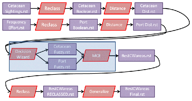
Figure 1 - Cartographic model of Best Cetacean Watching Areas
Go to the results of this analysis
Continue to Results