 |
|||||||||||||||||||||||||||||||||||||||||||||||||||||||||||||||||||||||||||||||||||
| Introduction |
Methodology
A multiple-criteria evaluation (MCE) using the weighted linear combination (WLC) method is chosen for the project because the factors are all flexible in suitability. It is unlikely to have one factor more important than the other, but rather each factor have a varying degree of suitability. For example, it is preferred that the depth of water be as deep as possible (after examining that all the locations is deeper than the minimum preferred) so there can be more fresh water moving through and the waste does not all concentrate near the bottom of the net. Yet usually deeper water exists only when far from shore. So getting too far away from the shore lost the protection from the shore, thus being in deeper water is offset by the lost of benefit from the shore. The idea of the project is to find suitable areas for salmon farming out of a winter set and a summer set, I will need to combine the two MCE-WLC results from the two seasons. Therefore the first part of the project in Idrisi starts in a parallel fashion for winter and summer to get each factor ready for MCE input. Based on the interpolated result, some areas have values out of the range suggested by the SAR. They are to be taken out by applying a binary mask created from the original layer, over itself (Figure 5). Various FUZZY set membership functions are applied to the different factors. Specific FUZZY settings are summarized in Table 1.
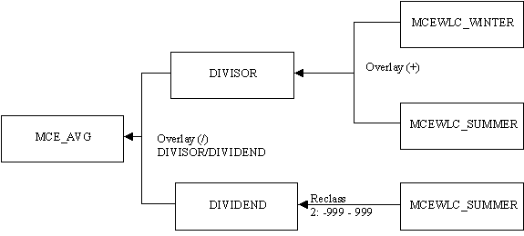
Again briefly speaking, the final steps involve combining the two MCE results. Once the MCEWLC_WINTER and MCEWLC_SUMMER is obtained, a Boolean MCE is created as a mask. This is because the WLC method will return a non-zero suitability factor if as long as a location is not 0 in all factors. Yet there are some locations where the value of the factor exists the recommended by SAR. Therefore these areas have to be cut out. On the other hand, I decided to combine the MCEWLC_WINTER and MCEWLC_SUMMER by averaging their suitability value. This is done as illustrated by Figure 6.
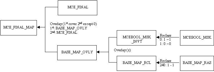
An interesting step is to prepare the land part. The land is shown as a part of the map with a distinct value. This is done thru the steps shown in Figure 7.
|
||||||||||||||||||||||||||||||||||||||||||||||||||||||||||||||||||||||||||||||||||
| Data Collection | |||||||||||||||||||||||||||||||||||||||||||||||||||||||||||||||||||||||||||||||||||
| Methodology | |||||||||||||||||||||||||||||||||||||||||||||||||||||||||||||||||||||||||||||||||||
| Spatial Analysis | |||||||||||||||||||||||||||||||||||||||||||||||||||||||||||||||||||||||||||||||||||
Fuzzy |
|||||||||||||||||||||||||||||||||||||||||||||||||||||||||||||||||||||||||||||||||||
MCE |
|||||||||||||||||||||||||||||||||||||||||||||||||||||||||||||||||||||||||||||||||||
Result |
|||||||||||||||||||||||||||||||||||||||||||||||||||||||||||||||||||||||||||||||||||
| Discussion | |||||||||||||||||||||||||||||||||||||||||||||||||||||||||||||||||||||||||||||||||||
| Conclusion | |||||||||||||||||||||||||||||||||||||||||||||||||||||||||||||||||||||||||||||||||||
| Email me | |||||||||||||||||||||||||||||||||||||||||||||||||||||||||||||||||||||||||||||||||||
 Figure 5
  Figure 6