|
Suggested Locations for the Placement of Environment Canada's New Hydrometric Stations in the Georgia Basin |
| Title Page |
| Introduction |
| Data |
| Methodology |
| Spatial Analysis |
| Problems & Errors |
| Conclusion |
DATA ACQUISITION AND MANIPULATION
All of my GIS coverages were supplied by Environment Canada, with the assistance of my old co-op supervisor, Paul Whitfield, and E.C's GIS specialist, Judy Kwan. I thank them for their assistance.
Digital Elevation Model
The underlying coverage for all my maps, in terms of presentation, was a 50-metre resolution DEM. This coverage was also essential for performing my slope analysis. Intuitively, it makes sense to have a coverage of the terrain of the Georgia Basin since hydrology is greatly influenced by such factors as landforms and elevation.
The DEM was provided in the form of a 25-metre GRID. This beast weighed in at 289 MBs and consisted of eight tiles. Working in ArcInfo Grid, I first merged the eight folders into one file, OUTGRID, using the MERGE command. Then I resampled OUTGRID, using the RESAMPLE command, to produce a 50-metre resolution DEM, called FIFTYGRID. For this, I used BILINEAR interpolation, the most appropriate type for elevation data. I resampled to a coarser resolution to reduce the huge amount of data, to reduce processing time of the slope analysis, and because I thought 25 metres was an unnecessarily high resolution given the large scope (the Georgia Basin) of the project.
To get the data into IDRISI, I first went to ArcView and used the Spatial Analyst extension to make a grid.apr project file and then an export file, xport.asc (ASCII data). In IDRISI, under Import, I used ARCRASTER which converts ArcInfo raster ASCII format into IDRISI format. This entire process took at least 12 hours, much of it problem solving.
The next step in bringing the DEM into IDRISI was critical, which was ensuring that the projection was okay. I had looked at the GRID files in ArcInfo and had learned that the projection for the projection was "Albers". Unfortunately, IDRISI only has Albers Hawaii, Albers Alaska, and Albers U.S. built into its system! This meant I had to build my own Albers B.C. file using tables of numbers in the IDRISI manual and values from the BC MELP website. Jasper helped me accomplish this (Thanks, Jasper!) and I now had a ALBERSBC.REF file which I used as the reference system in the metadata for all my coverages.
Finally, for this raster coverage which I called elevgrid, I created an elevation palette with colours I believed to be appropriate for representing the B.C. landscape. Since the file came into IDRISI with a weird scale, (-76 to 17,000 metres!), I had to adjust it in the metadata by changing the maximum and minimum values and display values to 3000 and 0, respectively.
Phew!!
Hydrometric Stations Coverage
Environment Canada provided me with a coverage of all of their current (2001) hydrometric stations for all of British Columbia. This coverage was originally an ArcView export file (.e00) and I used FME to convert it into IDRISI vector format. I adjusted its reference system to AlbersBC. Once into IDRISI, I painstakingly deleted all of the stations that were outside the boundary of the Georgia Basin, both from the image file and from the database. (I deleted about 300 of them, one by one. Maybe there was a faster way!) I also eliminated four stations that were missing values in their fields. I made a point symbol file.
I added new fields to the
database of 94 stations - the name of the major watershed group that each
station belonged to and the name of the hydrologic zone that each station
was situated in. By adding these fields, I was able to easily draw the
graphs, (by bringing the Stations database into Excel), shown in the Introduction,
as well as identify which watersheds and hydrologic zones are currently
under-represented by Environment Canada's hydrologic network.
Roads Coverage
Environment Canada supplied me with a transportation coverage which included ferry routes, electrical lines, pipelines, etc. Again, this coverage was an ArcView export file (.e00) that I converted to IDRISI vector format, using FME. I input the AlbersBC reference system into its metadata. Since all the transportation routes were identified only by code, I had to go to the government website, http://www.env.gov.bc.ca:8000/pls/feature_code/fcode.formquery, and type in all the codes to determine what everything was. Table 1 lists the codes and their descriptions.
Figure
10 illustrates the transportation network, in vector form. I converted
it to raster, in IDRISI, using LINERAS.
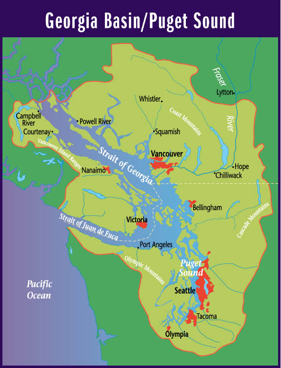
Georgia Basin Boundary Coverage
I also requested a coverage
of the boundary of the Georgia Basin (Canadian side). This was an ArcView
export file that I converted to IDRISI vector format, using FME. I changed
its reference system in its metadata to AlbersBC. I created a line symbol
file for it. (It is illustrated in several previous maps.)
 |