Data
My community garden data source had some flawed information. The Strathcona Garden is listed at Campbell Avenue and Prior Street and the Cottonwood Community Garden is listed at Prior Street and Hawks Avenue on the Vancouver Community Services website. When I geocoded the Cottonwood intersection it was off by about 2 blocks north and 1 block west. On another website, cityfarmer.org--listed the Strathcona Garden at Prior and Hawks and the Cottonwood Garden at around Malkin Ave between Chess and Raymur Avenues. When I was using Google Earth aid my digitization proccess I found out that information on cityfarmer.org is more accurate than the Vancouver Community Service website. Since I started and based my community garden data from an official source--the Vancouver Community Services website--I stayed with it and just altered that part of the data. I also know from having been to the Strathcona Garden that it is located at Prior Street and Hawks Avenue.
Another problem with the is that some of the community gardens were not visible in Google Earth because they are too recent. For those locations I used the intersection locations and approximated a small lot.. The proper method would have been to go out and find the actual place and approximate it's size however I did not alot enough time for myself to do it.
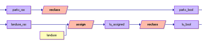
IDRISI
Initially I prepared most of my data in ArcMap and imported them into IDRISI. When I tried to use the DecisionWizard I got an error message telling me that the inputs were not all the same resolution. I started all my preparations again to find out next that my inputs were not all the same spatial converage. Finally on my third try I was successful. I did a few other things differently on third attempt. On my first and second attempt I converted all my files to raster and then ascii in ArcMap. When I imported the ascii files into IDRISI the background values were given -9999 and so I had to assign them 0 by creating an attribute file. On my third attempt I found a better method. As shown in my cartographic model I imported the shape files into IDRISI to get vector outputs which then I converted to raster with the file "blank" using the modules pointras, and polyras. When I created the file"blank" using the Initial module I predefined the spatial coverage and resolution. Contrary to my first and second attempt I got two birds with one stone using the "blank" file.
General
The greatest challenge was organization. I restarted a few times as a result of it. I got really confused as I progessed in disorder and decided that it was best to start over with a clean slate and a clear understanding of my data. I also greatly underestimated the amount of time needed to do this project properly.
I also had numerous struggles with Dreamweaver as it is only my second time using it. I restared a few layouts until I became more comfortable and familiar with Dreamweaver and produced this layout. The progess of the project flowed much more smoothly thereafter.