Methodological and Operational Problems
No major problems were encountered through the course of this project. Data aquisition proved to be more time consuming than expected. Many data sources were available, but finding and sorting through data to find information which matched the scope of this project was somewhat difficult.
The spatial resolution of several data sources were slightly lacking. A finer resolution for the GVRD DEM on which the spatial attributes of this project were based, would have allowed for more detailed analysis of smaller areas.
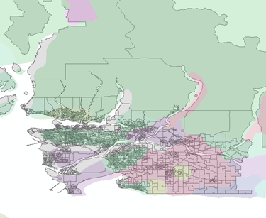
Finding data on surficial materials was difficult, I eventually had to settle for a 1:5,000,000 scale vector dataset for the province. The vector shapes were very rough, and in several places, did not cover parts of the study area. Manual editing of polygons in ArcMap was required to correct this prior to importing into IDRISI. This may have lead to some inaccuracy in determining the surficial material for certain areas.
Surficial data overlaid on top of dissemination area map. Note the differences in shape of the surficial data compared to the more ccurate shape of the dissemination area map.
Population data may have some inaccuracy as the population density for each dissemination area was used to determine the population residing in each cell. Larger dissemination areas may have residents living only in parts of the area, this would lead to inaccuracies in determining the number of people affected by each hazard.
Classifying rock types, age groups, and surficial materials proved to be an educational experience. I did not know quite a few of the definitions involved, but through looking them up and trying to understand their differences, I have increased my knowledge in these areas.
This was the first oppurtunity I had to perform raster analysis for a project. I've learned more about real world challenges I may face when dealing with projects of this type. Overall, I found this to be a somewhat challenging, but positive learning experience.
