Methodology

Home
Study Design and Hypothesis
Research Background
Data Sources
Methodology
Spatial Analysis
Conclusion
Problems and Discussion

1. Data Conversion and Generation
  
        A. Vegetation map was  in Arcview 3.2 format.  It has been imported into ArcMap 9.0 and the attributes were added and linked to original table. The projection was defined as UTM 43n, WGS 1984.
        B. Landuse map was generated by RECLASS function in ArcMap 9.0.  A grid file of  landuse was created  by exporting data, giving column as 1100, row 1450. This will automatically generated a cell size as 20 meters for the raster image.  Convert landuse raster image into ARCII format(test file) using ArcToolbox,  then this data is ready to import into IDRISI.
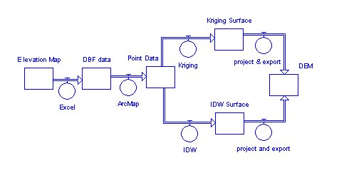
        C. Elevation data was recorded from secondary elevation map. The procedure of creating DEM data is shown on following diagram.
              DEMgen
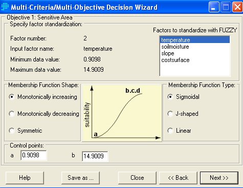
2. Multi-criteria Development
 
      A. Constraints
      The
constrains are Boolean images, which represent the different geographic regions as suitable with 1 value or not suitable with 0 value under any conditions.
      The landuse condition ( landcon ) was considered as one constraint in this project.  The areas with water, glaciers and gravels slope are not suitable for experimental area. Constrain image will be used to mark out the area that are constrained

       B. The factors are most important criteria
that define some degree of suitability for all geographic regions.  Individual factor scores may either enhance (with high scores) or detract (with low scores) the overall suitability of an alternative.  These factors are  standardized in a different ways to fit into suitability analysis.
        a. Landusefuzz was created by giving each landuse category a suitability value from 0 to 255 scale.
        b. Temperature surface was generated by using image calculator.  The relation between elevation and temperature is fitted  into a linear model.
        c. Soil moisture surface was generated using same method as temperature. But the relation between the elevation and soil moisture is fitted in to linear model.
        d. Slope surface is important environment factor in higher elevation mountain region. The slope image is created from DEM image.
        e. Cost surface is based on the distance travel from the research station and landuse types is assigned as different friction values.
    
3.  MCE_WLC
 
        A. Standardization of factors to a continuous scale
        The first factor has created outside of decision wizard as above. The temperature, soil moisture, slope and cost surface need to be transformed from the disparate measurement units of  factor images into comparable suitability values. The working experiences in this area give me a comprehensive knowledge to initialize fuzzy membership among the factors.
           a. Temperature factor is driving variable in alpine tundra ecosystem.  The average annual temperature is -2oC  at Haibei research Station. The temperature suitability is increased with the temperature going up. 
           b. Soil moisture is factor that indicates the water condition.  When the soil moisture is very wet or very dry, they will be considered as lower suitability.  The range between them will be considered as the best soil moisture suitability.
           c. Slope is less than 10 degree is considered as good slope suitability because  the areas are flat and where the typical vegetation type occurs. 
          d. Cost surface is considered as important factor that is related to  the travel distance and landuse types. The same type of landuse where it is near to Haibei Research station will have better cost surface suitability than these far away.

          B. Weighting Factors for Aggregation
          Choose the AHP option to derive the  weight for all factors. The following matrix shows the relative importance among the factors.                     

       WLCfactorcomp

The decision wizard will keep running and make final processing to create the most suitable areas for the experiment design.
       

PreviousPrevious                              Home                                      NextNext