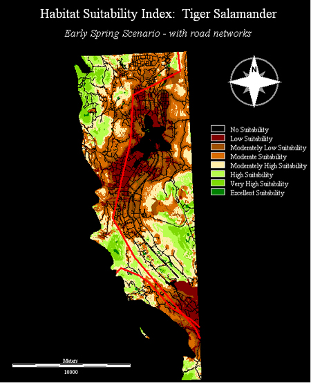

Based on studies conducted in August of 2008, a habitat suitability index for the Tiger Salamander based on four water bodies was developed to determine the level of suitability of these water bodies and their surrounding habitat. They all possessed different characteristics such as the slope of the banks, vegetation type and length of vegetation zones, impacts of humans and cattle, and finally water quality. The results from the analysis of the early spring and late summer MCE's produced for this class were fairly consistent with the results produced from the summer study. However, I felt the MCE's produced for this project provided a better representation of the varying suitability across water bodies of differing size as well as the landscape in general.
Specific information regarding water quality, intensity of human and cattle impact as well as the specific types and amounts of vegetation were not accounted for in the MCE. However, I felt the generalization by land-use type, biogeoclimatic zone, and size of water body represented these criteria quite well. Biogeoclimatic zones were used to indicate the natural vegetation of the region as well as the temperature needed for the tiger salamander to survive. The use of biogeoclimatic zones was a suitable replacement of vegetation type because the zones themselves (bunchgrass and Ponderosa Pine) are two vegetation types preferred by this species. The use of land-use type to indicate the intensities of human and cattle impact on the area was the weakest "replacement" factor. While it determined a relative degree of impact by humans and cattles ie: Rangelands and agriculture land-uses have higher impacts than in Old or Young forests, it was unable to indicate specific intensities of impacts at key places such as lake and pond boundaries. I attempted to remedy this problem by using the road network where suitability increased away from roads. I felt this factor provided a good representation of human impacts on or near roads. Combined with the land-use factor, rangelands with roads surrounding water bodies had a much lower level of suitability than rangelands without roads. This makes sense because a higher number of roads or access to water bodies by roads increases the risk of human and cattle impact.
Overall, I felt the MCE's provided a decent Habitat Suitability Index when compared to the study done in the summer. If a situation similar to the one produced by the climate change scenario were to occur, hotter and drier climates would lead to decreased amounts of suitable habitat and increased risk of habitat fragmentation. These trends can also be seen even at the short term scale between early spring and late summer months. This analysis could provide those concerned about the health of the tiger salamander populations a lsit of potential factors to take into account when developing management strategies designed to retain or increase the health of certain habitat.