
Data collection and more specifically, the quality of the data is an important aspect to consider when representing, studying, and revealing new information about real world phenomena. When developing a habitat suitability index for rare or endangered species such as the Tiger Salamander, obtaining information regarding their habitat is often difficult to find. Since such species are rare or endangered, the ability to locate and accurately determine where they live is very difficult due to low population numbers. Furthermore, the development of maps to represent where they might be located within a given region is often, but not always, a generalization of where they can be, rather than where they are.
The table below is a list of the original data sources used in this MCE. 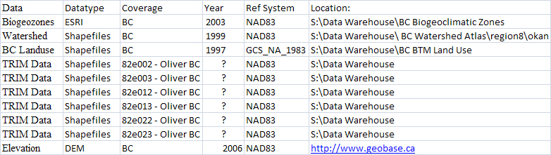
As mentioned above, the ability to find specific information about where the Tiger Salamander is located is very difficult. Due to the lack of specific locational information, the data that were chosen were based on key characteristics related to the habitat these salamanders require (for more information, refer back to the introduction page).
Information about the biogeoclimatic zones, watersheds and different landuses within BC were gathered from the datawarehouse in the SIS harddrive of the SIS computer lab at Simon Fraser University. Data concerning the elevation of the study region was found on the internet by searching through the database of the Geobase website (http://www.geobase.ca). The specific file used was a digital elevation model that represented the 82e04 study area (Oliver, BC). The Geobase website also had data concerning: canadian geodetic network, canadian geographical names, geopolitical boundaries, national hydro network, national road network, and satellite imagery. However, this information was not necessary for my specific needs.
Lastly, high resolution TRIM data was acquired from Christopher Au-yeung that provided a variety of information regarding the surrounding water bodies (lakes, ponds, streams, rivers), as well as the surrounding road network from Oliver to Osoyoos.
Information regarding the variables used, data manipulation and extraction is discussed on the Methodology page.