Priority Counties for Rainwater Harvesting on the Ogallala Aquifer, Texas
Reclass # |
Combination of factors present |
New Suitability Value |
| 6 | IBTs | 255 |
| 2 | GCDs | 220 |
| 8 | GCDs + IBTs | 215 |
| 1 | PGMAs | 190 |
| 3 | PGMAs + GCDs | 180 |
| 10 | SW | 70 |
| 16 | SW + IBT | 65 |
| 12 | SW + GCDs | 40 |
| 18 | SW + IBT + GCD | 35 |
| 11 | SW + PGMAs | 20 |
| 13 | SW + PGMAs + GCDs | 0 |
Interpretation
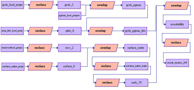
Areas that only contain IBTs were considered most suitable for rainwater harvesting (most in need of water conservation) because the IBTs are only proposed transfers that may or may not come to fruition. In addition, IBTs affect only small areas relative to the other criteria. GCDs were also ranked as highly suitable, not because they are ineffective, but because PGMAs and SW have a far greater impact on water conservation. Areas that contained a combination of SW, PGMAs and GCDs were ranked as least suitable (suitablity value of 0) due to the high potential in these areas to conserve groundwater. Some combinations were not present, for example the combination of all four factors (SW, PGMAs, GCDs and IBTs) did not occur anywhere within the Ogallala counties. Combinations that were not present were not included in this table.
| Home | Introduction | Data aquisition | Methodology | Spatial analysis | Discussion/results | Problems |
|---|
Spatial analysis cont'd |
|---|