Priority Counties for Rainwater Harvesting on the Ogallala Aquifer, Texas
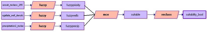
Each of the three factor outputs (actually seven factors if the four factors of the governance/surface water index are counted) were input to the Idrisi Decision Wizard to prepare them for the multi-criteria evaluation. Factor images were created using the Fuzzy operation in the Decision Wizard.
Setting MCE objectives
Each factor was then treated as monotonically increasing with a J-shaped increase for precipitation, the curve evening out at a value of 5 (of 6) to differentiate the two regions with the least precipitation from the other regions, but in a gradual way. Well density was treated as a linear increase because well density is directly proportional to water scarcity in the region. A well density value of 37 (of 47) was used as the levelling point for the increase to separate the ten counties with the greatest density. Because well density was considered the largest contributing factor to groundwater withdrawals and because this study is intended to isolate the top ten counties for a rainwater harvesting program, it made sense to treat these top ten counties as one maximum value. The governance/surface water suitability index was assigned a sigmoidal increase pattern because the maximum values in the index corresponded to factors that were significantly more important in determining suitabilty than the minimum values. For example, areas where only GCDs were present were more suitable because they contained substantially less potential for groundwater conservation than a combination of GCDs with large surface water coverage.
Pairwise comparison
Both precipitation and well density were treated as the most important factors in the pairwise comparison. Precipitation is the only way the Ogallala aquifer can achieve recharge so it was treated as extremely more important than governance or the presense of surface water. Without precipitation, the density of wells is really an inconsequential factor, the aquifer would stand no chance of replenishing its water without rainfall, therefore, precipitation was also treated as strongly more important than well density. At the same time, well density is the largest contributing factor to groundwater withdrawals from the Ogallala. While the presence of government conservation programs and surface water can alleviate this stress, they are still somewhat less important than well density.
| Precip | Gov/SW | Well Dens | |
| Precip | 1 | 1/9 | 1/7 |
| Gov/SW | 9 | 1 | 3 |
| Well Dens | 7 | 1/3 | 1 |
Suitability map
The three eigenvector factor weights were input to the MCE to generate a suitability map which was then reclassified into a boolean format to reflect areas with maximum suitability in ten different counties. It was found that reclassifying the suitability results 0-240 as 0 and from 241-255 as 1 generated a boolean map with a value of 1 present in only 10 different counties. see map
| Precip | 0.0549 |
| Gov/SW | 0.6554 |
| Well Dens | 0.2897 |
| Home | Introduction | Data aquisition | Methodology | Spatial analysis | Discussion/results | Problems |
|---|
Spatial analysis cont'd |
|---|