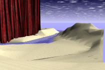
The task of this game is to create and understand several terrain models of a given site. Terrain modelling in form•Z is a generic tool that can be applied not only to the modelling of landforms but also to a variety of problems. You are to create four terrain models using the model provided (the model gives a site outline and a set of contour lines).
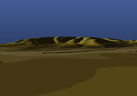
- The first model is to be a mesh model of the entire site with a mesh of 2000mm.
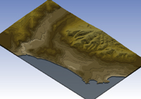
- The second model is to be a triangulated contour model of the entire site (generally known in CAD as a triangulated irregular network or TIN).
- The third model is to be a stepped model of the entire site.
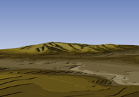
- The fourth model is to be a triangulated irregular network for those parts of the creek that are below 4000 in elevation and a mesh model (with a mesh of 2 000) for the rest of the site (two blocks, north and south of the creek).
The first three models should be easy to do. You merely have to prepick the site contours and use the terrain tool with the appropriate settings picked in the dialog box.
The fourth model is more difficult. It is both an important kind of model to learn how to create and an example of how, in CAD, you must often develop a plan using several operations in order to create a particular object. The reasons you need to create models that combine different kinds of terrain models are several:
- Different landforms have different shapes that are better represented with one tool than with another.
- Different parts of a site contain contourinformation at different densities (or, equivalently, frequencies). This means that a modelling technique that is good for one part of a site may not be the best, or even acceptable, in another part of the site. The site you have been given has contour lines that are particularly close together where they define a creek bed and much further apart where over the rest of the land. This implies that a mesh model, at a resolution reasonable over the rest of the model will insufficiently sample the creek area. This will result in a nonsensical form. The creek is best modelled with a triangulated irregular net. The rest of the site is better modelled with a mesh as this gives the best approximation to the smoothly changing landform that is the actual site.
|