Background
Our project is to use the wide range of GIS technology to develop new ways of showcasing the Coast Mountain Trail Series. Using GPS data gathered from Strava and given route data, we will be producing interactive, dynamic and easy to use maps and geovisualization products. We will be using 3D technology, game engines, fly over techniques, and 2D maps to showcase each race route. We will be creating an online platform to share these maps with other trail racing enthusiasts. Our goal is to be able to produce meaningful and valuable geovisualization techniques that are beneficial to the athletes running in the Coast Mountain Trail Series.

Ultramarathons and trail running have in recent years grown exponentially as a sport for runners seeking an endurance adventure. Although there is growing interest in competition of this sport, there is little published on the demographics of ultra runners and the trends associated with participating in the sport.
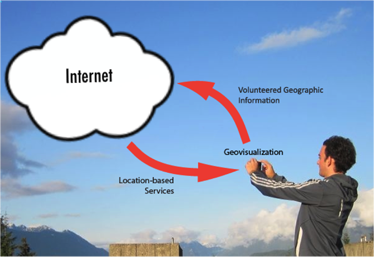
Volunteer geographic information (VGI) and GPS tracking via smart watches or smart phones is becoming an increasingly popular tool to track trail routes, run times, and even one's heart rate. VGI has become increasingly popular with natural resource applications, especially with the planning of recreational trails. Not only is VGI an inexpensive way of gathering information, but by gathering information via a smartphone is user friendly, and it is highly accessible to anyone. Once gathered, this spatial data can be posted onto online sharing platforms, such as Strava, in order to share up to date routes

Additionally, GIS technology is highly in demand in the information era. Although, GIS software enables advanced spatial analysis, they are mostly limited to 2D or 2.5D static maps, but in recent years, 3D modelling especially in the gaming industry made significant advancements. Moreover, GIS has integrated with Internet application and uses web platforms, which is called Web GIS. We can make our outputs as mobile apps, online maps, 3D models and so on. The change of GIS technology is also the change of maps. Many cartographers believe that the role of map is a medium of communication; it supports “visual thinking and decision making”. Interactive map and Web GIS have become popular trends and users do not need to be GIS specialists, they can interact with the apps or maps by just clicking or moving their mouse.