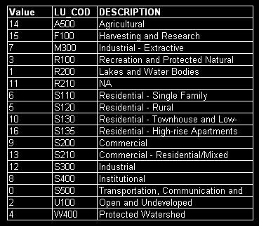
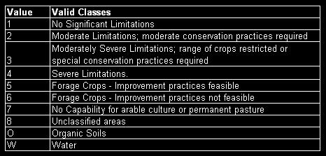
Both the Boolean and the MCE analyses used the metadata provided in the text files of both base maps. This information was used throughout the project for ASSIGN and RECLASS functions, as well as general reference. The most commonly used information were the keys revealing which numbers corresponded with which map element.
GVRD Landuse Descriptions:
Soil Quality Descriptions:
BOOLEAN ANALYSIS
The final boolean map doesn't tell us much about the suitability of land for agriculture in the Lower Mainland. However, it does give us an idea of how much land is available.
According to the boolean result, there is 53.8 square kilometers of suitable agricultural land available in the Lower Mainland; that is compared with the 475.3 square kilometers of suitable soil, and the 1957.2 square kilometers of unsuitable agricultural regions. When viewed in this context, it doesn't seem like a lot.
However, this result must be analyzed further, as it only shows areas with 100% suitability. To view the final boolean map, see results.
MCE ANALYSIS
The original final output for the MCE looked like this. In order to create feasible categories, a RECLASS function had to be performed using macro modeler:
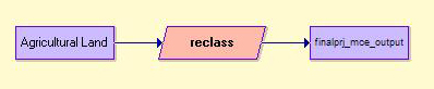
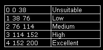
The RECLASS file looked like this:
The final output shows us that although there are few ideal places with 100% suitability available for agriculture in the Lower Mainland, there are places that fit some but not all of the criteria. This could mean, for example, that the area is too close to residential regions, but also very close to commercial areas; or that water is not nearby, but residential areas are far enough away. Planners would find this information very useful in making land use decisions. This analysis did not apply weights to the criteria because all factors are largely of equal importance; and the constraints are of utmost importance.
Overall, this analysis has sought to show areas of suitability for agricultural practices in the Lower Mainland. The purpose is to try and increase the amount of local farming that occurs here. Last year, the Agricultural Land Reserve had a net loss of land totalling 10.7 ha in Greater Vancouver. This is concerning because the south coast only amounts to 4% of the total land reserve. Most of the excluded land comes from private interests, though government also plays a role. Thus, it is of great importance that we conserve the remaining land suitable for agriculture so future generations do not have to worry about where their food comes from.
To view the final MCE map, see results.