|
Methodology
2
Criteria
Weighting:
As there were a
large number of factors present
in locating both stations, all
with varying levels of importance,
it was necessary to use specific
procedures to determine relative
importance of criteria. Using
simple pairwise comparison of
factors in the context of a sound
decision making process, we are
able to determine relative weights
of factors, summing to one. Pairwise
comparison was completed using
the 9 point continuous scale of
IDRISI's WEIGHT module. Upon initiation,
the module derives factor weights
by calculating the principal eigenvector
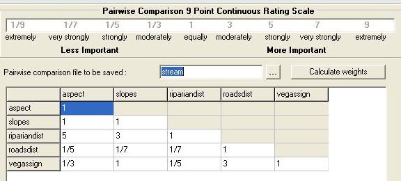
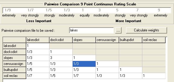
of the input pariwise comparison
matrix (pictured below).
STREAM
STATION WEIGHTING

The eigenvector
of weights is :
aspect
: 0.1799
slopes : 0.1683
ripariandist
: 0.5093
roadsdist : 0.0388
vegassign : 0.1037
Consistency
ratio = 0.07
Consistency is acceptable.
LAKE
STATION WEIGHTING

The eigenvector of weights
is :
littoraldist
: 0.4149
docksdist : 0.1580
slopes : 0.2451
censusassign
: 0.0743
builtupdist :
0.0743
soil reclas :
0.0333
Consistency
ratio = 0.04
Consistency is acceptable.
Weighted
Linear Combination Multi-Criteria
Evaluation:
The
weighted linear combination multi-criteria
evaluation multiplies each standardized
factor image by its factor weight
and sums these for results. As
each set of factor weights must
sum to one, the resulting final
suitability map will have the
same range as that which was used
previously for standardization
of factors (ie. 0-255 in this
case). Multiplication of this
result by constraint images results
in non-inclusion of constraint
areas in final suitability analysis.
Once the final suitability map
had been generated using MCE for
both stations, sites of suitability
> 225 were determined and grouped
into spatially contiguous areas.
The sites with largest contiguous
area and suitability > 225
were selected as the final site
locations for both stations. The
cartographic model below shows
how this was carried out for both
stations.
DETERMINING
AREAS
NEXT
|