|
Data
Sources, Processing and Manipulation:
The
elevation data for the Lake Tahoe
basin was obtained from the Lake
Tahoe Data Clearinghouse as a
digital elevation model of resolution
10m, derived from 4 USGS topographic
quadrangle maps as well as hypsographic
data using photogrammetric methods.
The original DEM was converted
to an Arcraster ASCII file which
was employed to create the raster
image used for spatial analysis.
DEM
IDRISI
Road
data, stream and lake data, as
well as human-made object data
(docks, wharfs and built up areas)
were obtained from the Lake Tahoe
Data Clearinghouse as published
by the USGS. All were obtained
in ARC INFO format requiring conversion
to raster images. The lake data
also required re-projection.
Land
cover data was obtained from the
Environmental Protection Agency,
derived from a mosaic of 18 Landsat
images. Land cover was divided
into 8 major catagories, each
of which contained various levels
of subdivision. Additional vegetation
cover data was obtained from the
Lake Tahoe Data Clearinghouse.
These data were obtained in ARC
INFO format, with the vegetation
data requiring re-projection.
LAND
COVER & VEGETATION
Soil
data in the form of a ARC INFO,
Natural Resource Conservation
Service soil map for the Lake
Tahoe Basin was obtained from
the SSURGO Database. This file
required reprojection as well
as conversion to a raster image.
Census
data were derived from US Census
Bureau TIGER files. The final
data were obtained in ARC INFO
format from the Lake Tahoe Data
Clearinghouse and the final census
tract boundaries from the US Census
Bureau. This data set was originially
much too large in volume requiring
much data filtering to include
only necessary population statistics
and the census tract boundaries
which they pertain to. Much of
the population data required conversion
to metric units in ARCMap.
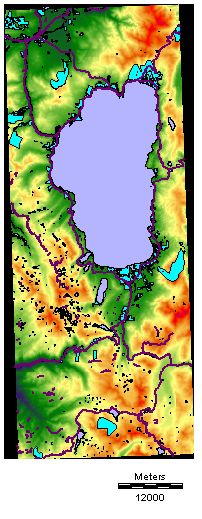
DEM
image with lakes, built up area
and road vector layers.

NEXT
|