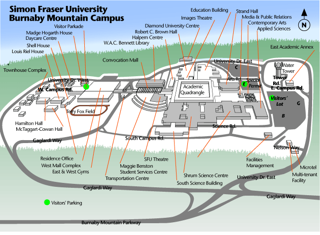
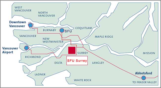
Maps of Burnaby Campus:
Most of the activies happening for orientation occure on
the Burnaby campus (except SFU-Surrey's Orientation). More specifically,
many oientation activies are happening in the Convocation Mall.
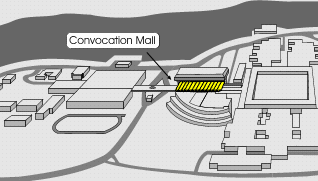

click to enlarge
back to top
Maps
of Harbor Centre:
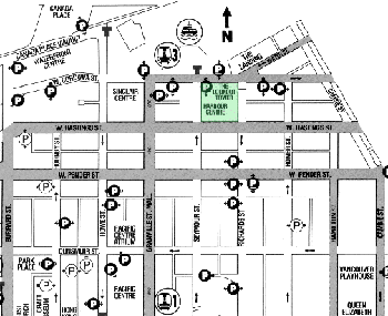
click to enlarge
back to top
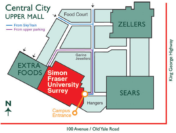
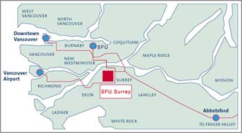
Maps
of SFU-Surrey:
back to top
Miscellaneous
SFU Map:
click to enlarge
back to top
How
to get to Burnaby Campus:
You can also use mapquest for driving directions and maps.
From the East:
Trans-Canada Highway (Highway 1) going west -- take the Gaglardi
Way exit 37.
Lougheed Highway (Highway 7) going west -- turn right (north) onto Gaglardi
Way. Follow straight
From the West:
Trans-Canada Highway (Highway 1) going east -- take the Gaglardi
Way exit 37.
Lougheed Highway (Highway 7) going east -- turn left (north) at Gaglardi Way.
Hastings Street (Highway 7A) going east -- take the right
lane exit at the traffic light at Barnet Highway (just past
a pedestrian overpass). Continue onto Burnaby Mountain Parkway. From the South:
Trans-Canada Highway (Highway 1) going north west -- take
the Gaglardi Way exit 37.
From the Vancouver airport:
Take Marine Way (east). Turn left (north) onto Boundary Rd.
Turn right (east) onto Lougheed Highway. Turn left (north)
onto Gaglardi Way.
back to top
How
to get to the SFU-Surrey Campus:
You can also use mapquest for directions and maps.
From SFU Burnaby
Head down the hill on Gaglardi
After you cross the Lougheed Highway, turn LEFT onto Cariboo and go up the
hill to Tenth
Turn RIGHT on Tenth, then LEFT on McBride (to the Patullo Bridge)
Cross the Patullo Bridge and go up King George Highway
Central City will be on your right between 102 and 100 Avenue. Turn right on
Old Yale/100th, and take the second right up the ramp to the upper level parking
From Downtown Vancouver
Get onto Hastings Street and drive east
Remain on Hastings through East Vancouver and turn RIGHT onto the Highway 1
eastbound ramp
Continue on Highway 1 and cross over the Port Mann Bridge
Take exit number 48 shortly after the bridge (108th Avenue/152nd Street exit)
Keep right on the off ramp and merge onto 152nd Street southbound
Drive past the 108th Avenue turnoff and continue up to the 104th Avenue intersection
Turn right on 104th Avenue and continue westbound to King George Highway
Turn left on King George Highway and continue southbound past 102nd Avenue
Central City/SFU Surrey will be to your right as you drive between 102nd Ave
and 100th Ave (Old Yale Road) on King George Highway.
Turn right on 100th (Old Yale Road), and take the second right up the ramp
to the upper level parking
From Vancouver Airport (Richmond)
Leave the terminal and merge into Grant McConachie Way (the
main airport causeway)
At the first intersection heading eastbound, turn RIGHT and
then immediately LEFT onto Miller road
Continue eastbound on Miller Road and cross the bridge where Miller Road
becomes Sea Island Way
Continue eastbound on Sea Island Way/Miller Road and keep right, merging
onto the Highway 99 southbound ramp
Drive southbound on Highway 99 and take exit number 37 (North Delta/New Westminster)
Follow the off ramp as it merges into highway 91a and continue on 91a over
the Alex Fraser Bridge
Keep to the right as you cross the bridge and take the first exit on the
other side
Keep left on the bridge exit and loop around back over the highway and onto
Nordel Way
Continue eastbound on Nordel Way as it crosses over Scott Road and becomes
88th Avenue
Continue on 88th Avenue/Nordel Way until you come to King George Highway
Turn LEFT on King George Highway
Continue northbound on King George Highway until you reach 100th Avenue
Turn LEFT on 100th Avenue/Old Yale Road and take the second right, up the
ramp to the upper level parking
From the Fraser Valley
Find Highway 1 and head Westbound
Take exit number 50 (104th Avenue), keeping left on the off
ramp
Follow the off ramp over the bridge and merge into 104th
Avenue
Continue on 104th Avenue westbound to King George Highway
Turn LEFT on King George Highway
Central City/SFU Surrey will be located to your right as
you drive between 102nd and 100th Avenue/Old Yale Road on
King
George Highway.
Turn right on 100th (Old Yale Road), take the second right,
up the ramp to the upper level parking
Directions via Transit
Exit the SkyTrain or bus at the Surrey Central station. Central
City/SFU Surrey is across 102 Avenue. Enter the mall via
the pedestrian access on the north
side of the mall.
For detailed bus routes and times visit http://www.translink.bc.ca/.
back to top
Transit
Information:
For detailed bus routes and times visit http://www.translink.bc.ca/.
SFU Transit Services: http://www.sfu.ca/bctransit/
back to top
|