Methodology
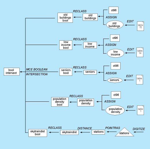
The spatial analysis of my project is is rather simple one. I have researched and determined certain factors that reflect the suitablility of a race track's location. Some factors are taken from true historical analyses, while others have been determined through research with the automotive racing industry. In North America, both road racing and oval racing is prevalent. In this case, temporary street circuits are of consideration. In order to maximize output at this stage, I have produced a cartographic model using Macromedia Freehand. The model shows the steps I used to produce my first final product. Here is the model:
Instead of including the parameters of each RECLASS operation within the model, I have included each RECLASS COMMAND FILE below:
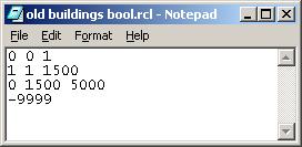
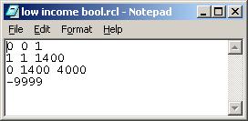
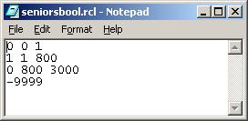
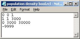
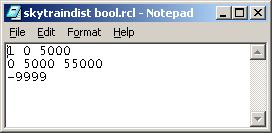
These parameters for the most part have been selected by myself. The distcance of 5 km from Skytrain stations was suggested by Stuart Ballantyne. The others were adjust in order to produce suitable areas in the final product. I did not want to produce to many areas that are only adequate, nor did I want to produce one extrremely suitable pocket of land. I attempted to separate each field from others by approximately the same ratio.
I conducted a Multi-Criteria Evaluation using these factors(old buildings, low income, seniors, population density) and contraints(skytrain distance). I also conducted a MCE using only population density and skytrain distance. This operation produced a raster image with much more suitable areas. This operation was conducted to satisfy my own curiosity.