MAPPING MALTA
Cartography, mapping and 2-dimensional representations of space are key aspects of the course. After looking at histories and contexts of maps and map-making, students were assigned to develop a map of Malta, which includes real data as well as fictional material.
Topics were geographical maps of borders (Air, Land and Sea space have and had different borders at different times), as well as movement of people. The assignment was to create maps based on "real" data and research material, but also have a component which is purely speculative, but which follows the logic of the collected data. For example we looked at research about climate change and the effects of raising sea level.
Through Sabine Bitters' involvement in the project Fleeting Territories this assignment became a case-study and the opportunity to participate in “Dal-Baħar Madwarha” (The Island is what the sea surrounds), the major multi-site exhibition as part of Valletta 2018, Cultural Capital of Europe. Fleeting Territories is a temporary collective by Austrian artists Sabine Bitter, Helmut Weber, Klaus Schafler and Swedish curator Jonatan Habib Engqvist.
Maps by students realized in class:
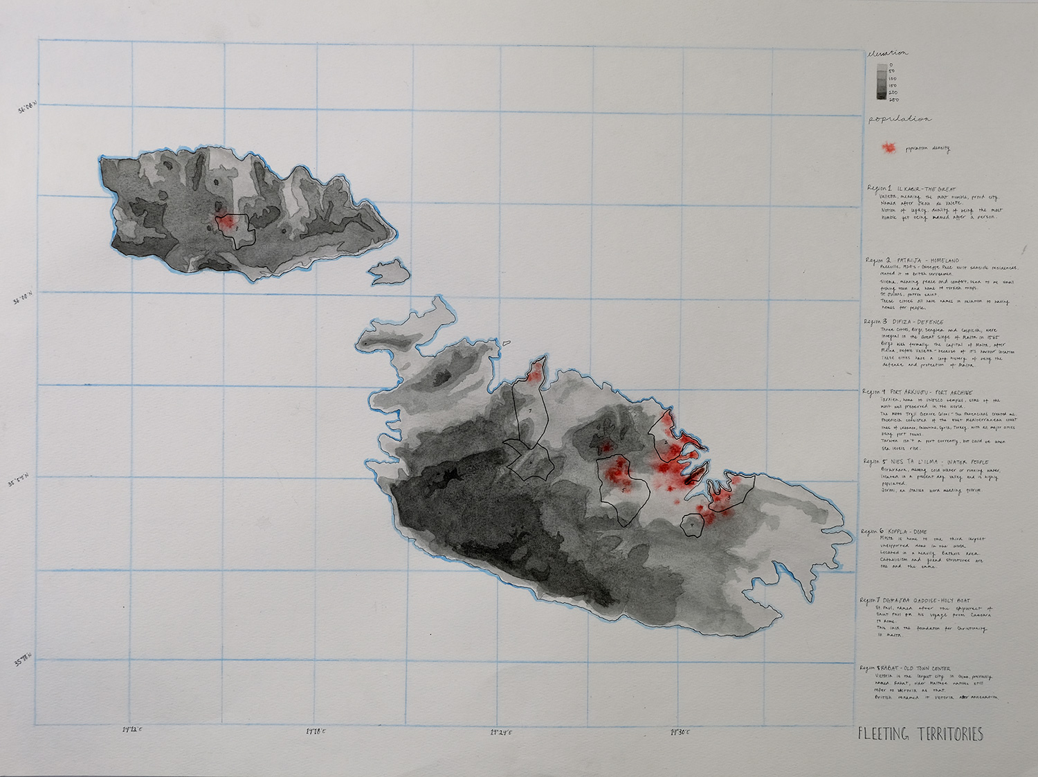 In our map, we wanted to speculate how Malta would change as the sea levels rose – or specifically, what they would change. We felt that Malta would not simply let itself sink, and that people would instead decide to take matters into their own hands, damming up the areas that they felt was most important – especially to the tourism industry, which is Malta’s largest industry. Taking this idea, and drawing from our research, geographically and demographically, we chose 8 districts that we felt Malta would dam up and save, and renamed them according to research done on historical contexts of the districts. We also denoted the population density in red, and the elevation in greys, with the lightest greys being the first to sink underwater.
Jana Ghimire
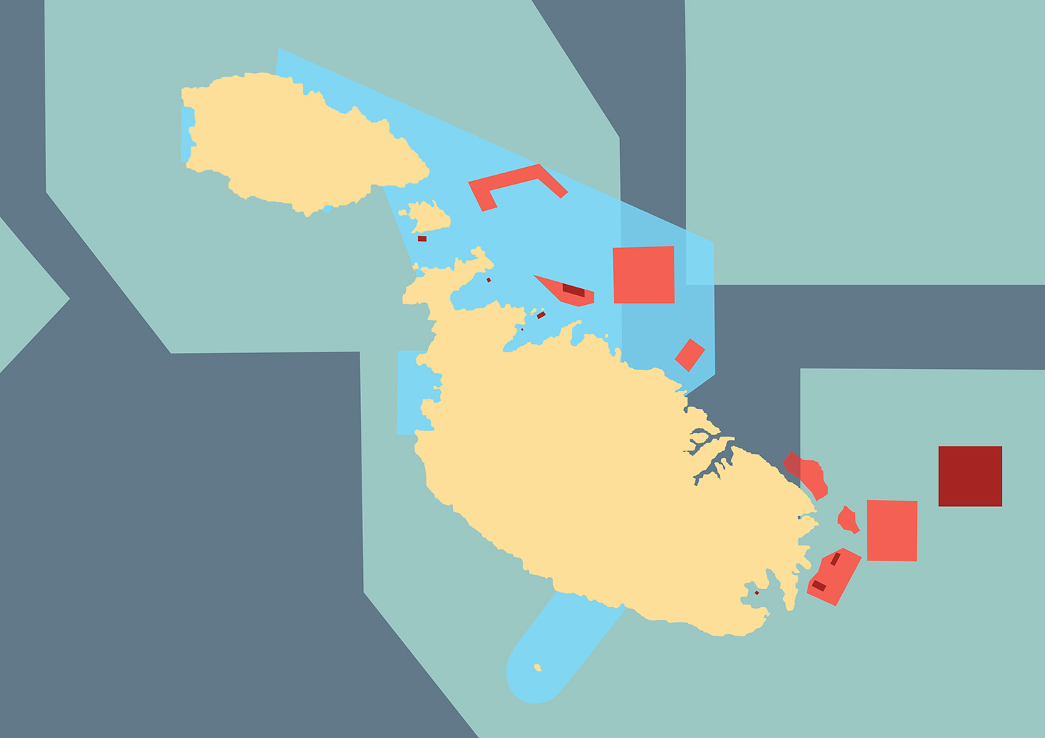 Although relatively small in land mass, Malta is surprisingly expansive in its maritime territory, which undoubtedly impacts local and global fishing and oil industries. After doing my own research related to Maltese maritimes, I discovered several maps that seem somewhat contradictory in their content. Some maps show ecological protection while others designate fishable “aquaculture” sites---there are areas where these literally overlap.
 I have visually combined several recent maps. Existing protected waters (light blue) hug the land (yellow), while several of the eight new Special Protection Areas (SPAs) expand outwards (sea green). Yet in 2016, the very same year in which the SPAs were approved by the European Commission, it would appear that the Maltese government had also proposed new aquaculture sites (orange), which are not only bigger than the existing ones (red) but exist in the new “protected” areas. With crisp lines fictitiously slicing through sea, this compilation of contradictory zones indicates that water is subject to just as much man-made bias and conflict as the land.
Elisha Wang
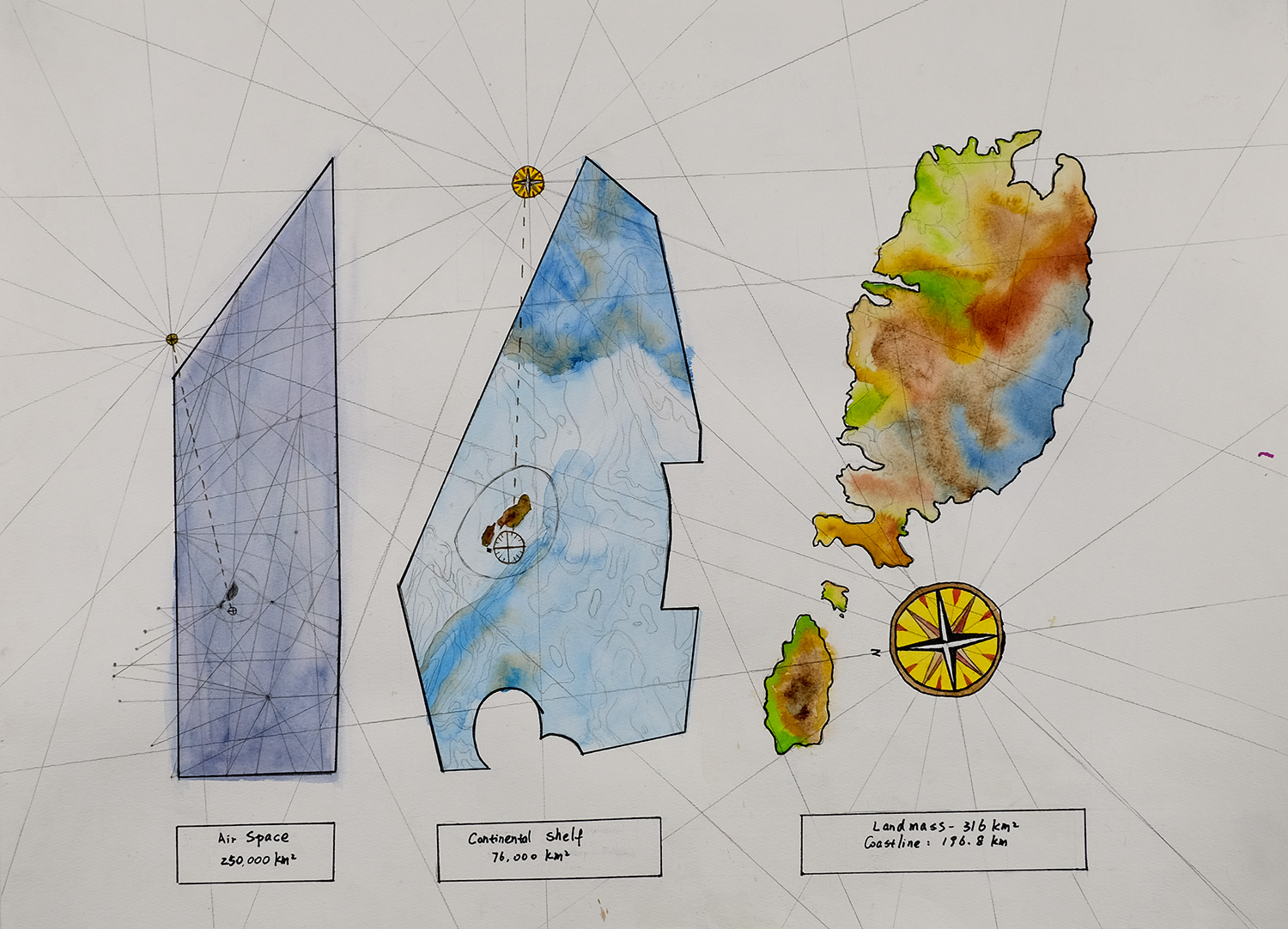 The map I created for this exhibition looks at the land of Malta in 3 different geographical perspectives. From left to right, it presents the map of Malta and its location within the air border, continental shelf, territorial water and the land. Through my research process of making this map, I was interested in the idea of the comparison and relationship between the different borders. Therefore, instead of having the borders true to size, I decided to draw the airspace, continental shelf and Malta with the same width to show how big the land of Malta is in relationship with each individual border/space. I also drew 3 compass roses on the map that indicates the location of Malta. The idea was inspired by the old maps of Malta that has multipole compass roses on one map.
 Carolina Krawczyk
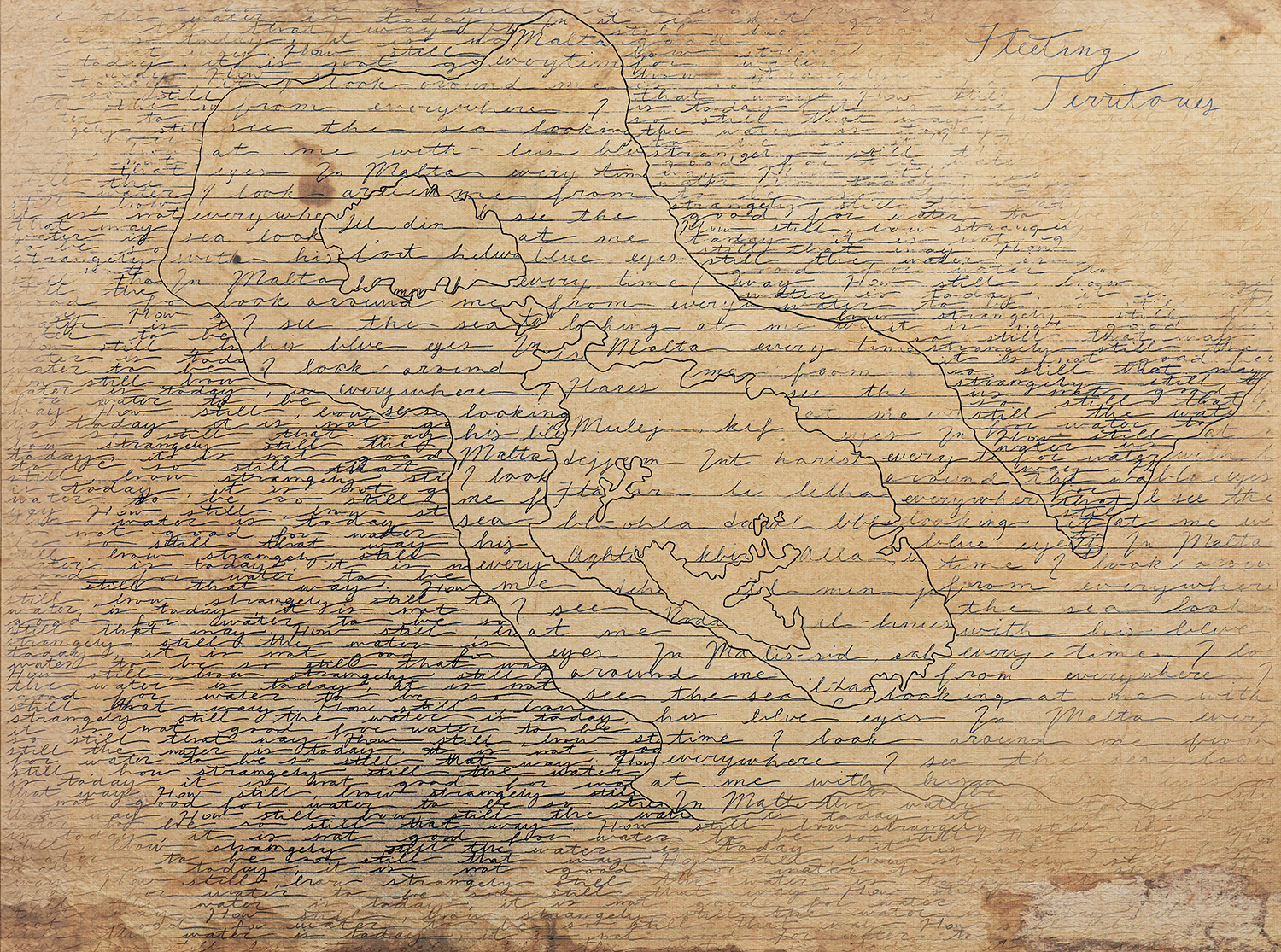 Fleeting Territories 2018 is a map work that uses language to depict speculative land masses and what they were at one point. In this work the spectator sees song and poem illustrating the land and what it has and might become due to water levels rising. The Malta geographical border as we know is filled with the Maltese National Anthem in its native tongue. The land that once was connected to surrounding countries is now flooded with the poem “Malta’s Sea” by Anton Buttigieg. The deepest waters we know today has the poem “Sea Calm” by Langston Hughes throughout it. By using language to depict the dangers of land loss, the audience reflects on a poetic telling of what was lost, made and will be.
Carmen Wong
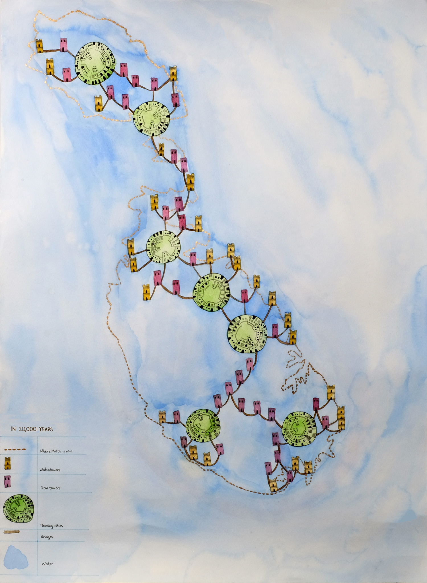 My map shows what could happen to Malta in 20,000 years. The land is completely underwater because the water level is slowly rising. People would live in tall buildings that extend over the water. I have included towers where people would live in; there are shops inside that provide essential items like toiletries. The towers are connected by bridges so people would be able to visit other towers. There are floating cities that are also connected to the bridges; they are communal areas for bigger events, shops and businesses. The brown buildings are the watchtowers of Malta; they are renovated to support a lot of people. The red buildings are newer and are there to provide more rest stops between buildings and cities. I referenced an old map of Malta with its beautiful and delicate line art of buildings; the map also had a gold border around the land.
Kitty Walker
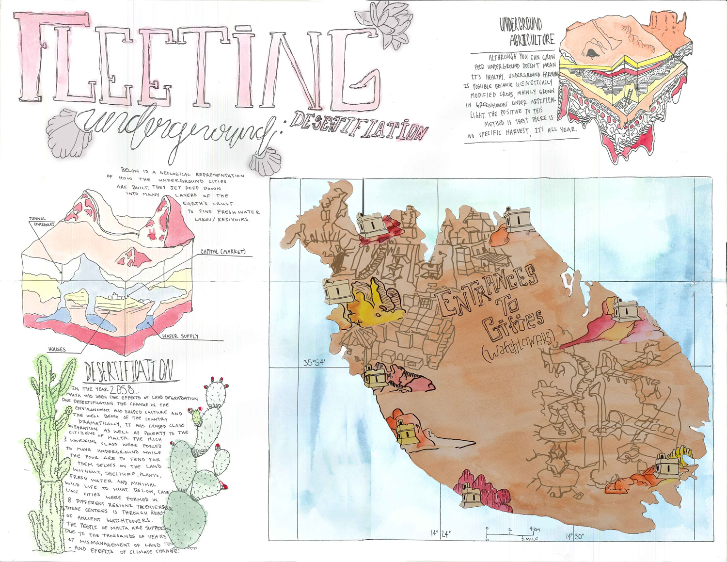 In my poster, Fleeting Underground, I explored the effects of Desertification and how they might disrupt the normal routine of the people of Malta. I created a fictional narrative about the effects of Desertification causing inhabitants of the country to migrate underground to fleet from the dangers of Desertification. My interpretation of this environmental catastrophe formed a dystopian division, creating a class separation with the higher classes moving underground forming cities and innovating unique ways of living. While above ground the underprivileged are forced to return to the social and economic structure of the hunter-gatherer civilizations. Although, my plot for my visual narrative is illusory the effects of desertification are very real. Desertification diminishes the ability to live off the land which affects plant growth, wild species, domestic animals and agricultural crops ultimately making the land uninhabitable. Overgrazing, deforestation, development and the effects of global warming are just a handful of the reasons desertification happens. Although, my plot is illusory the effects are very real and are presenting them self currently.
Rachel Warwick
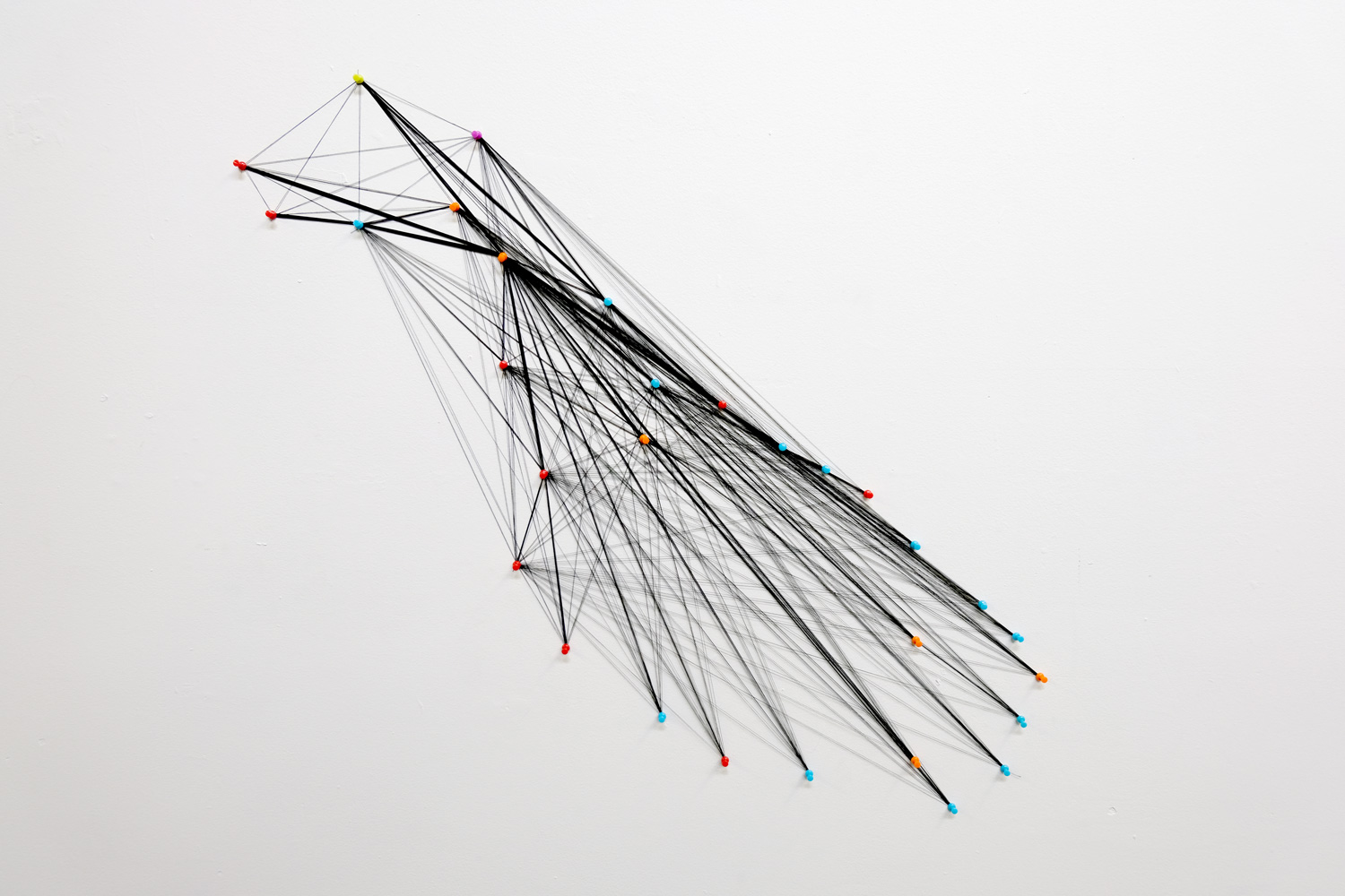 The sculptural map works upon suggestive means of mapping through what Deleuze and Guattari would describe as a rhizome and what James Corner believed to be an agency of mapping. This agency could begin to also suggest Corners ideas of mapping as a means to emancipate, enrich, and diversify worlds. The map has to do with performance of what is and what is not yet. The sculptural string installation is means of representing all the possibilities that may occur for the island of Malta. As well as speaking upon similar post-minimalist possibilities of ephemeral connectivity. Time connected with gravity, temperature, and atmosphere all become possibilities for Malta’s success or downfall. There are roughly 900 possibilities displayed in the installation, and becomes up to the audience to speculate exactly what.
Keting Dong
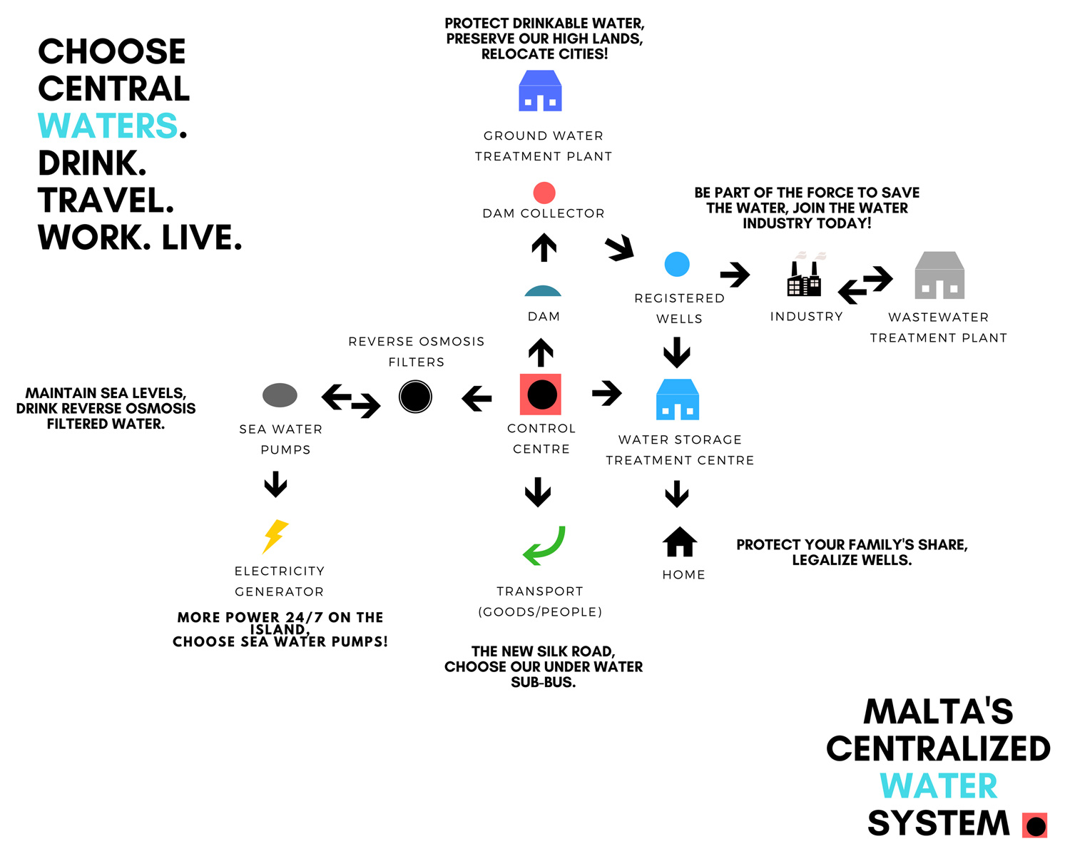
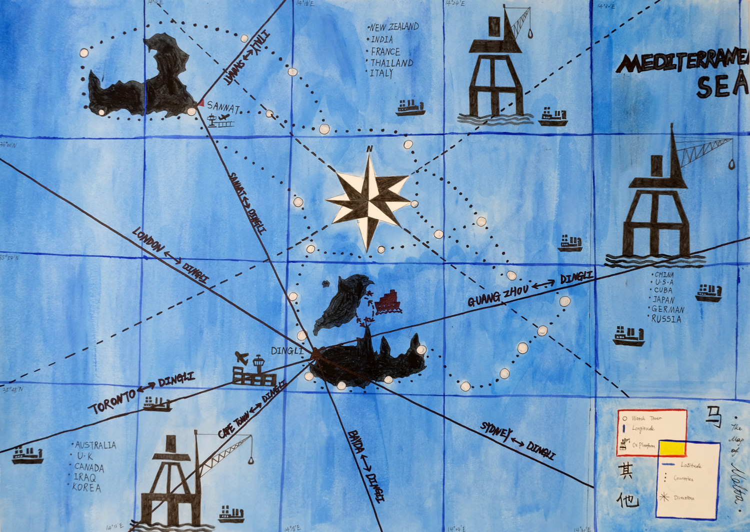 My Malta map is all about transportation and communication among different countries. I assume that Malta will disappear in 2000 years, but not the whole land, only Highlands left. People relies on the only lands in Malta. Some watch towers are still exist, I use white circles to represent those watch towers, I connect those watch towers by using the black points to show the original territory of Malta. In my map, I have six airlines which connects Malta to other cities, such as Guang Zhou, London and so on. Malta will become a station that connects different countries. I focus on how Malta communicate to the world and how the world interacting with Malta. Based on my research, there are many rich oil sources around Malta. So I assume that Malta government will develop and build the oil platforms around these areas, and attracting different countries to get oil resources which will help Malta to develop the local economy. Malta will eventually be known by the world. The rich oil resources and transportation methods will lead Malta to a good future, a future in 2000 years. The reason I put three Chinese words on my map is that they are representing my identity as a Chinese map designer.
Jesse Fernandez
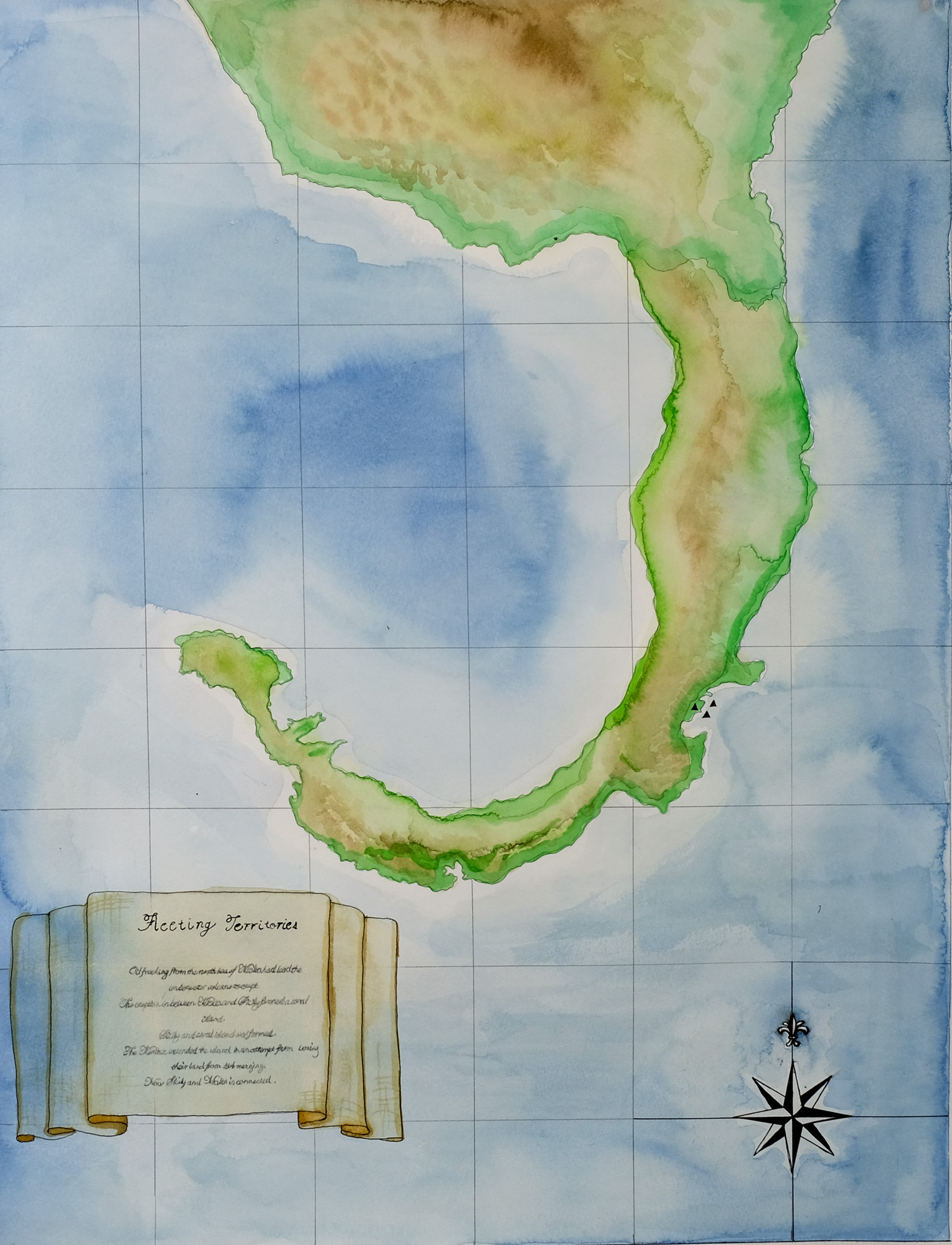
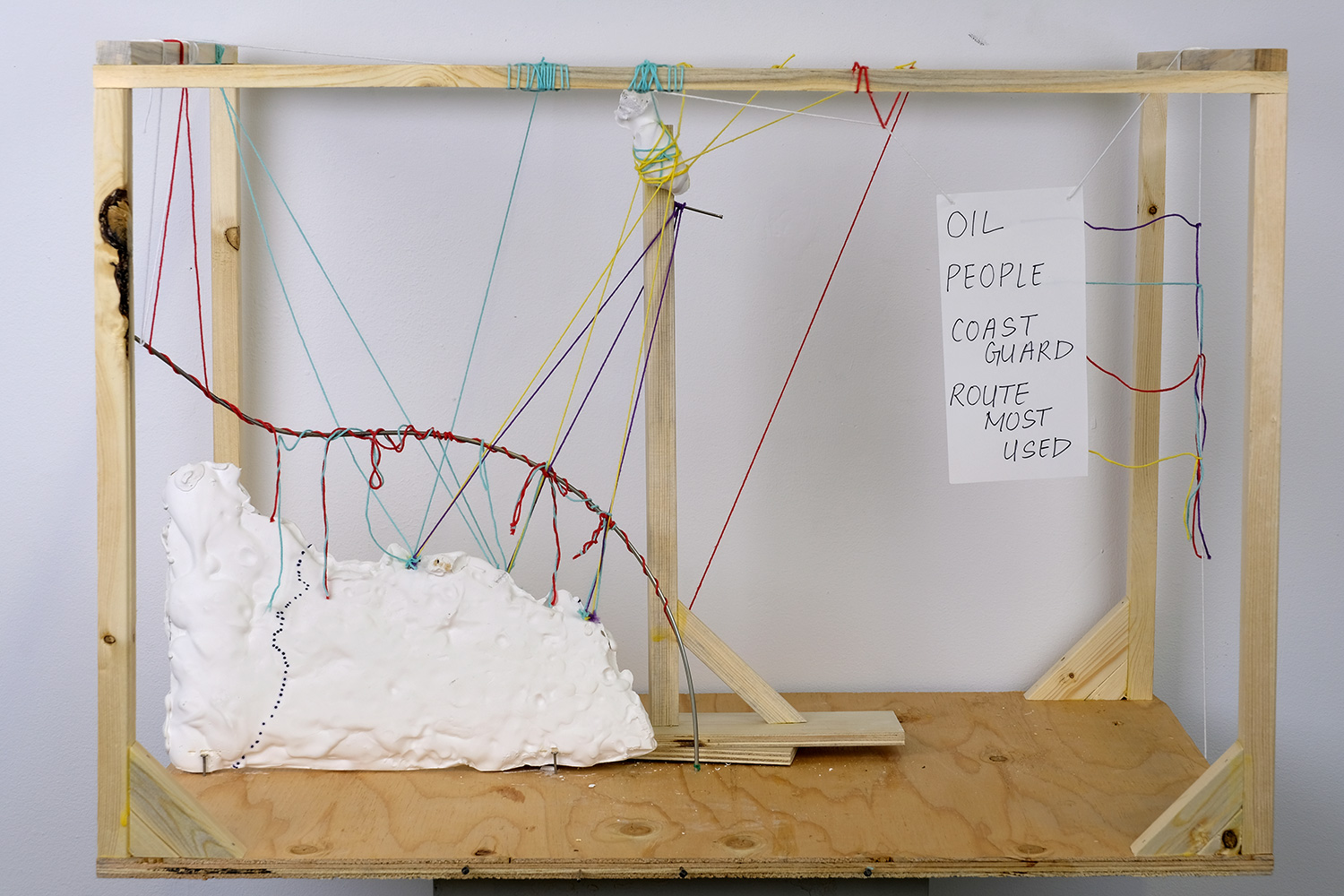 The piece gathers data from new’s articles and map’s and combines them, to model the complex set of relations between Malta and one of it’s neighbouring countries Libya. The data collected consists of; routes refugees take out of Libya, routes Libyan oil tankers use when trading with the EU (specifically Malta), Most popular commercial traveled routes(from Libya-EU), and the area in-which the EU funded Libyan Coast Guard occupies in the sea between Libya and Malta. The routes intertwine, passover one-another adding complexity to the relation between the two. I also wanted to start a discussion with this piece about “borders,” not whether or not we should build or break some more down. But what it the word may means, and then how to re-consider the border with this sculpture present. The piece again provides a simple way of viewing the movement of things that make up a complex set of relations. And aims to make the viewer question their basic understanding of borders both physical and phycological.
 Gillian Lai and Abbey Zhang
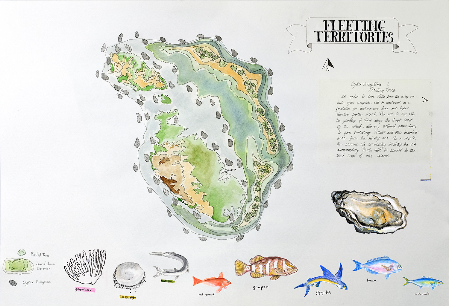 The main focus of my Malta map is to speculate about the building of new land in the future to prevent Malta from being submerged underwater due to the rising sea levels. The foundation for the new land is based on man made structures underwater that support underwater ecosystems, mainly oyster ecosystems, in order to create a natural architecture in which to build new land on. This new land will be based on sand dune ecology, rising the elevation of the land in order to protect the island from the rising sea levels. The project will start with planting trees along the coast of the new land in order for sand from the beaches to slowly and naturally form around the tree trunks in order to create higher elevation. This project will undoubtedly affect the marine life surrounding the island, therefore the marine life will have to be mortgaged towards the south west coast of the Malta. (Gillian Lai)
The combination of sheer cliffs, caves wrecks, shelves and sandy rocky sea beds mean there is a large variety of fauna and flora in Maltese waters. Normally, the water temperature was usually around 27 degrees average. However, it increased to 31°c already and will continually rise to about 3 more degrees in the near future which will highly affect the marine life in Maltese area. In the composition of my map, the left bright vivid colored fishes are the fauna living in the Malta area. On the other side, the uncolored species are those have been affected by rising water temperature. More specifically, needle fishes would appear earlier than usual, gorgonians suffered from mass mortality and fried egg jellyfishes increased in the presence. Aesthetically, the five colored fishes were positioned from cool tone to warm tone. The grid composition was inspired by decorative map from CARTE à BORDURES, CARTE à FIGURES.(Abbey Zhang)
Tina Alidaei and Ivan So
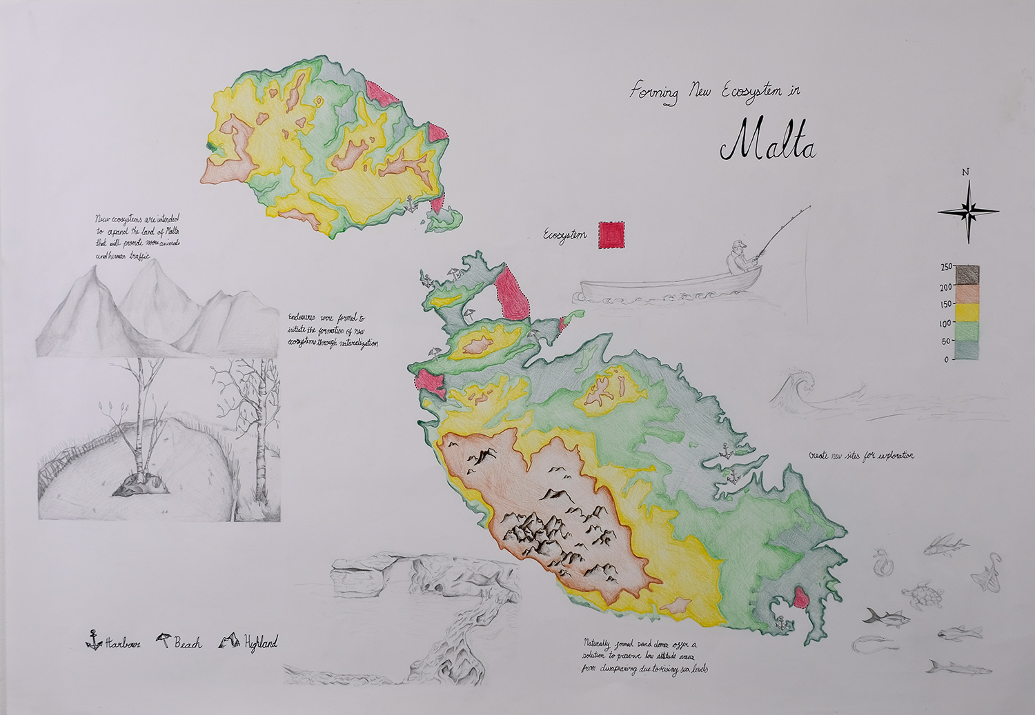 This prospective map of Malta shows the benefits of building ecosystems along the perimeter of Malta, such as increasing outdoor human traffic and increasing animal populations through naturalization. This idea derived from the man-made ecosystem that naturalized in Vancouver called Hinge Park. The goal of this hypothetical idea would be to build a mount of soil and sand that could encapsulate a portion of water around the borders of Malta. As a result, this new enclosure will catalyze the formation of new vegetation and animal habitats. Another benefit of this ecosystem installation would be to plant trees along the low altitude areas. This will allow sand domes to naturally form around the base of trees and increase the altitude of the land around it. Consequently, the higher land will help counter rising water levels and ultimately reduce the loss of land in the future.
June Yeo
Phoebe Huang
Victoria Tai
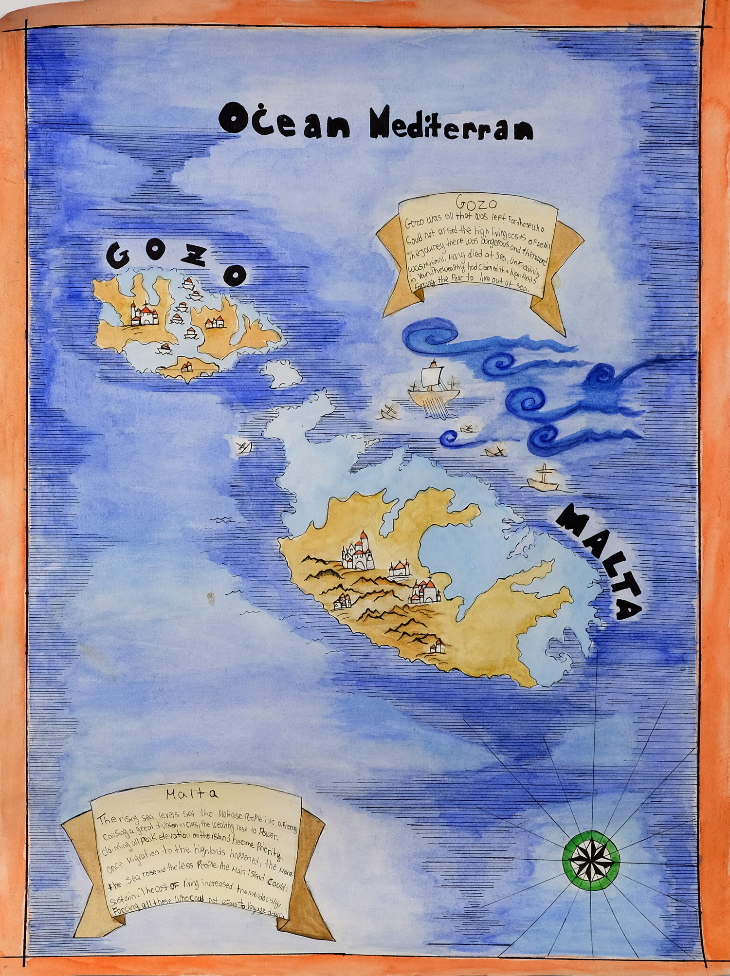 This map is based on the relationship between class structure, division and conflict in a dystopian society. The Maltese people are forced to move to high ground as the rising sea leaves start to overtake the island, leaving less land for the population to live on. Which leads cost of living to rise, as well as a definitive upper and lower class division. I was inspired by cartoonish and old maps as I felt it portrayed the dystopian or unrealistic ideas that my narrative followed. Although based on fiction, the negative outcomes of rising cost of living is a very real reality for thousands and thousands of people globally. Perhaps meaning that this narrative is not too far off if global warming continues at this rate.
Tyler Pengelly
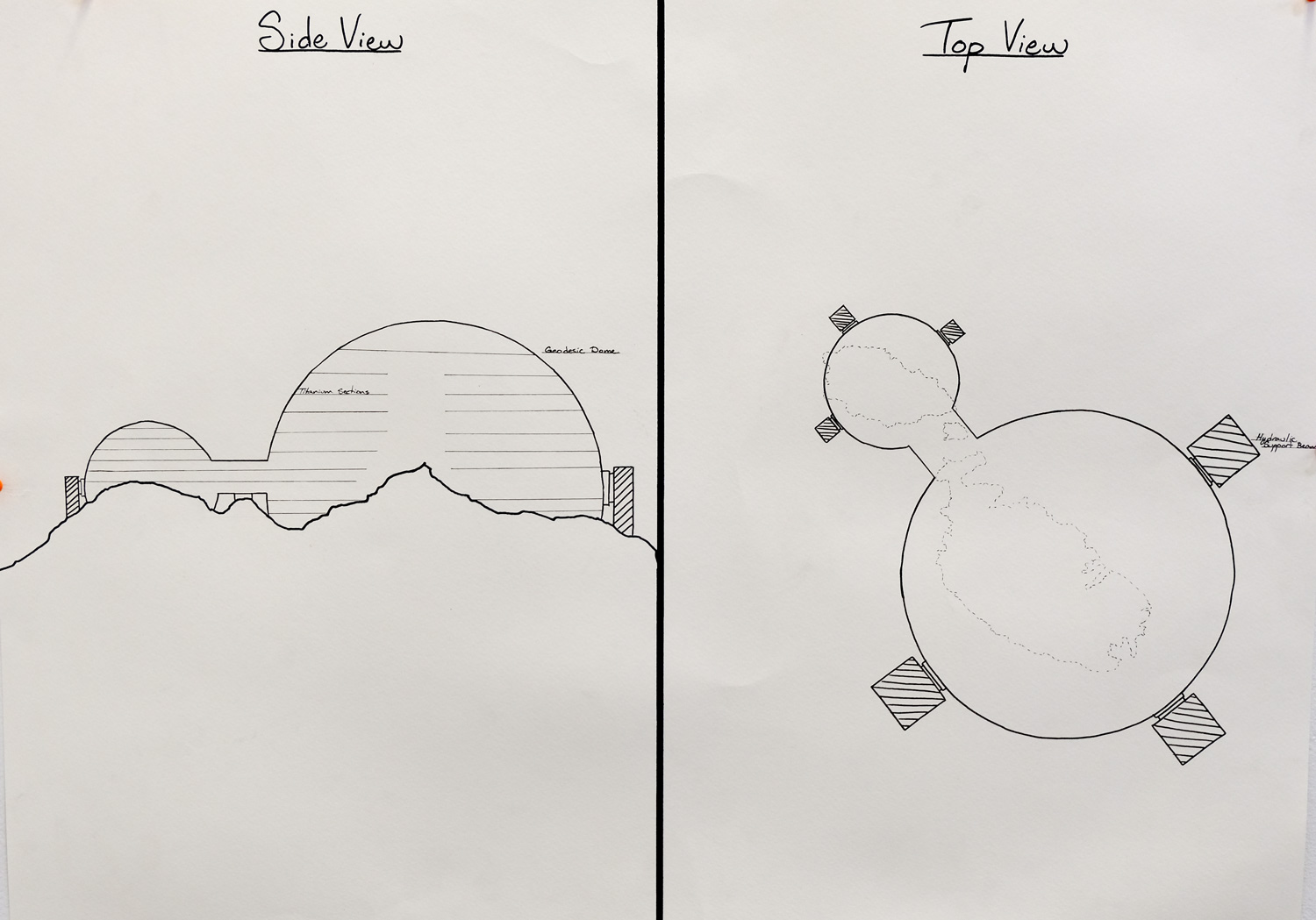 The map I created shows a dystopic future, wherein the residents of Malta have contracted the construction of a dome around the island. This dome will protect the island from water levels as they rise due to climate change. The dome will have everything provided and will make Malta a sustainable place to live. They will not need to import goods from other places. Everything they need will be created in house, which helps to solidify their bond with each other and protect them. The design for the dome is based around past models of geodesic domes. This map takes the form of an architectural blueprint. Using a modified format, it best shows the different views of the dome and how it will work.
Mason Rezazadeh
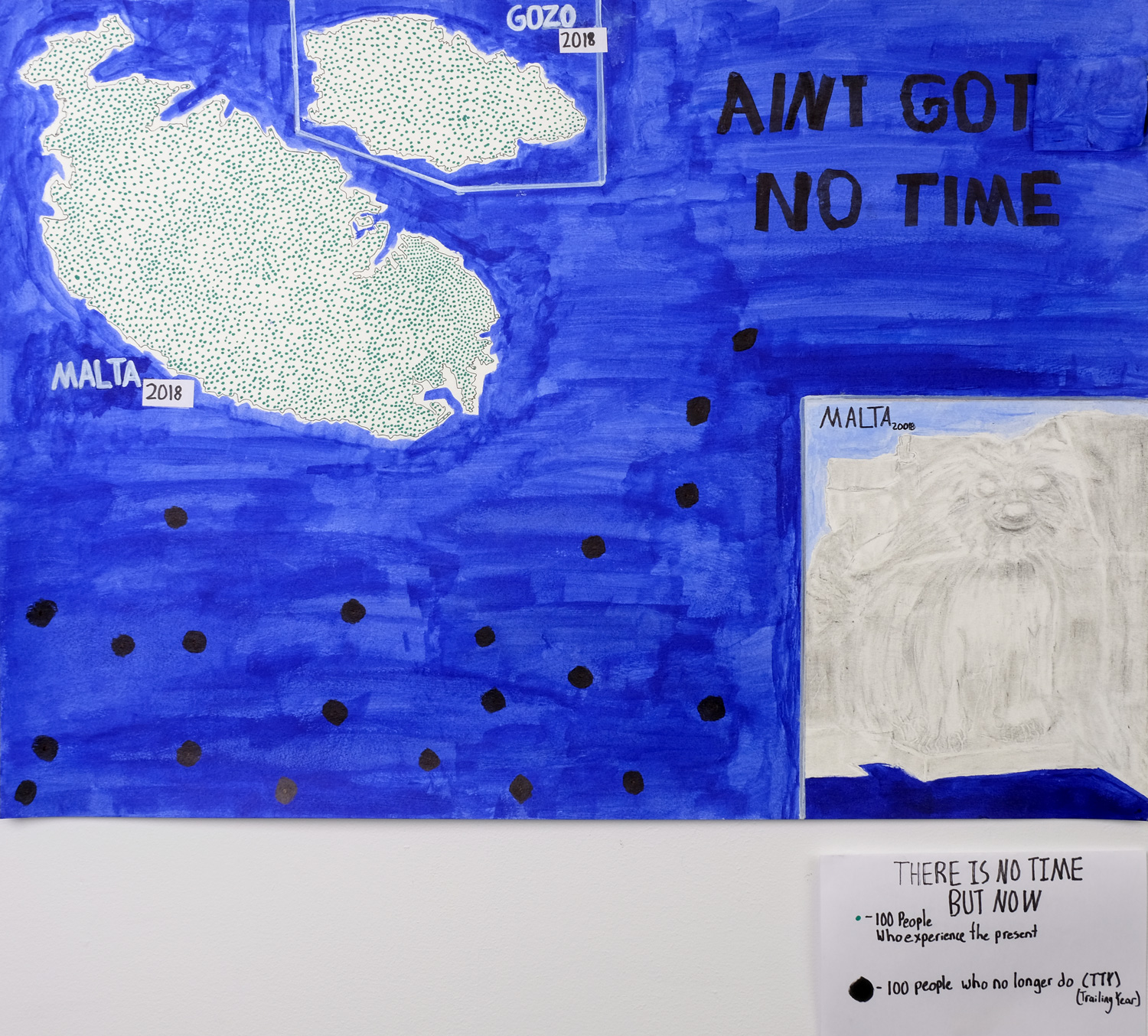 436,947 people live in Malta. From the start of 2017 until June, 2000 Migrants have died in the Mediterranean Sea putting 2017 on pace to being the deadliest year on record. Each dot represents 200 lives. There is some evidence that Maltese dogs descend from the Tibetan Terrier. Some experts speculate that they made their way to Europe through the Middle East with the migration of nomadic tribes.
Haylee Marx
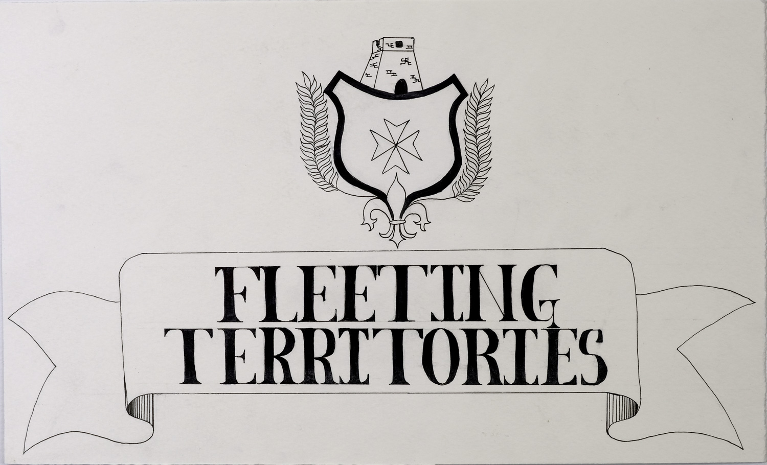 Instead of doing a map, I drew up a cartouche with the title “Fleeting Territories” in it. The cartouche is decorative, the border resembling a simple scroll or ribbon of sorts, and on top I designed a crest with some specific elements relating to Malta. Inside the crest is the Maltese Cross, a symbol associated with the Order of St. John. On top of the crest is a coastal watchtower, specifically one of the de Redin towers, an emblem which can be found on the Commander of the Armed Forces’ Pennant. The two branches with leaves sprouting from the crest are common additions to crests, and are also found on the Presidential standard flag of Malta. The fleur-de-lis is often used in European flags and on maps. The significance here is that fleur-de-lis were heraldic symbols of Wignacourt, and in 1610, Grandmaster Wignacourt had an aqueduct built which was adorned with an ornamental gateway with three sculpted fleur-de-lis on it. This context was the reason for naming of the suburb Fleur-de-Lys.