The methodology for this project was directed by research on the the
Marbled Murrelet's habitat. Murrelets are dependant on specific forest type for
nesting, Coastal Western Hemlock (CWH), Coastal Douglas Fur (CDF) and Western Hemlock (WH). As well, they require proximity to the ocean for food. Thus habitat analysis required data on forest type and age as well as information on distance to the sea.
I received three coverages for this project are called BECZONE BCLAND OLDFOREST. The
three files were in Arcview Shapefile format. I prepared them in Arcview before transfering to IDRISI.
Removing all unwanted BEC Zones
The BEC Zone file covers the entire province; however Marbled Murrelets only occurs in three of these CDF, CWH and MH all the other zones were removed. In ARCVIEW, I created a new field called ‘forest type’ and copied over the BECZONE values, CDF, MH, CDF wherever they occurred. I then created a NEW Shapefile called BECZONES2 which had only the CDF CWH and MH beczones.
I created a polygon in the shape of my study area (a square around Vancouver Island) to be used as a cookie cutter and cut the BEC Zone coverage to that square.
Determining Areas of Old forest within my study area
The OLD FOREST file contained areas of old forest for the entire province. I reduced the data tables in ARC/VIEW and clipped OLDFOREST with a cookie cutter creating a file that had only old forest areas within my study area.
Determining the areas of old forest within the BEC zones
Within OLDFOREST there are areas of old forest that OUTSIDE one of the three BECZONES. Since only old forest areas within one of the three CDF, MH, or CWH are of interest, all areas of old forest that exist outside these zones had to be removed. I made a shape file of the BEC zones and used it to clip the OLD FOREST leaving one file that was old forest in the shape of the BEC Zone
Final product in Arc/View
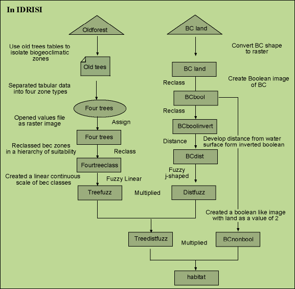
I was left with two maps of the Vancouver Island area as a study area: Old forest and BCland which were imported into IDRISI and further processing is depicted in the following cartographic model.


