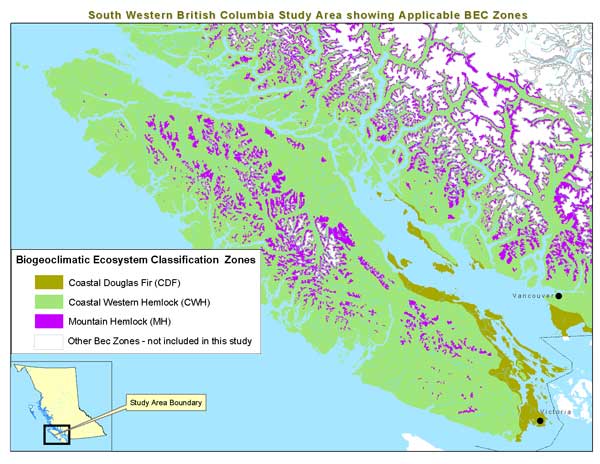
is used as a measure of habitat diversity.
It divides the province into climatic units called Zones that are further divided into smaller units
(sub-zones and variants). In addition to climate, BEC is based on vegetation cover, topography, soils,
vegetation succession and productivity. Operational scale is 1:250,000.
This BEC data was used to help determine areas of suitable habitat for marbelled murlett.
There are three specific BEC Zone in British Columbia where marbled murlett may be found.
The three BEC Zones are:
1.Coastal Douglas Fir (CDF)
2.Mountain Hemlock (MH)
3.Coastal Western Hemlock (CWH)
Click on the thumbnail below to see a full screen map of the province showing these three zones
as well as the area of study for this project.
NAME: Biogeoclimatic Ecosystem Classification System (BEC Zones)
Source: BC Ministry of Sustainable Resource Management (MSRM), Forest Research Branch
Original File Format: Arc/Info vector
Projection: Albers Equal Area Conic, NAD 83
Scale: 1:250,000
Distribution: Public. This digital file is available for download from MSRM’s FTP located at:
Further Information: http://www.for.gov.bc.ca/research/becweb

Baseline Thematic Mapping data (BTM)
Depicts generalized land use and land cover for the province and is derived primarily from satellite imagery plus the integration of various digital and analog sources. Operational scale is 1:250,000.
Since only old forest land is of value for Marbled Murrelet habitat , all other BTM classifications such as urban areas, recently logged areas, or alpine areas, were not needed for this project. BTM old forest is defined as forest over the age of 140 years.
Distribution: Limited.
Permission for use of this data set was granted from Decision Support Services, MSRM in Victoria. Use is limited to this project.
NAME: Baseline Thematic Mapping data (BTM) Old Forest Theme
Source: BC Ministry of Sustainable Resource Management (MSRM), Forest Research Branch
Original File Format: Arc/Info vector
Projection: Albers Equal Area Conic, NAD 83
Scale: 1:250,000
Distribution: Restricted. Permission received to use this data from Dave Minty, BC Ministry of Sustainable Resource Management (MSRM), Decision Support Services, Victoria.
Further Information: http://home.gdbc.gov.bc.ca/products/btm.htm

Coastline and Land Border of British Columbia
This digital file contains the coastline and land areas for the province of British Columbia at a scale of 1:250,000. This file was necessary in order to create distance buffers from shorelines as well as determining the total land base of my study area, since my study area includes areas over salt water and land areas outside of B.C., (ie parts of Washinton State).
NAME: Coastline and Land Border of British Columbia
Source: Crown Land Registry Services (Surveyor General)
Original File Format: Arc/Info vector
Projection: Albers Equal Area Conic, NAD 83
Scale: 1:250,000
Distribution: Public.
Background sources for Marbled Murrelet habitat
http://www.speciesatrisk.gc.ca/Species/English/SearchDetail.cfm?SpeciesID=39
http://www.wildcalifornia.org/projects/endangered_species/marbled_murrelet.html
http://www.sfu.ca/biology/wildberg/bertram/mamurt/research.htm#nest
http://www.fs.fed.us/database/feis/animals/bird/brma/biological_data_and_habitat_requirements.html
http://www.wcel.org/4976/28/01/11.asp


