Methodology
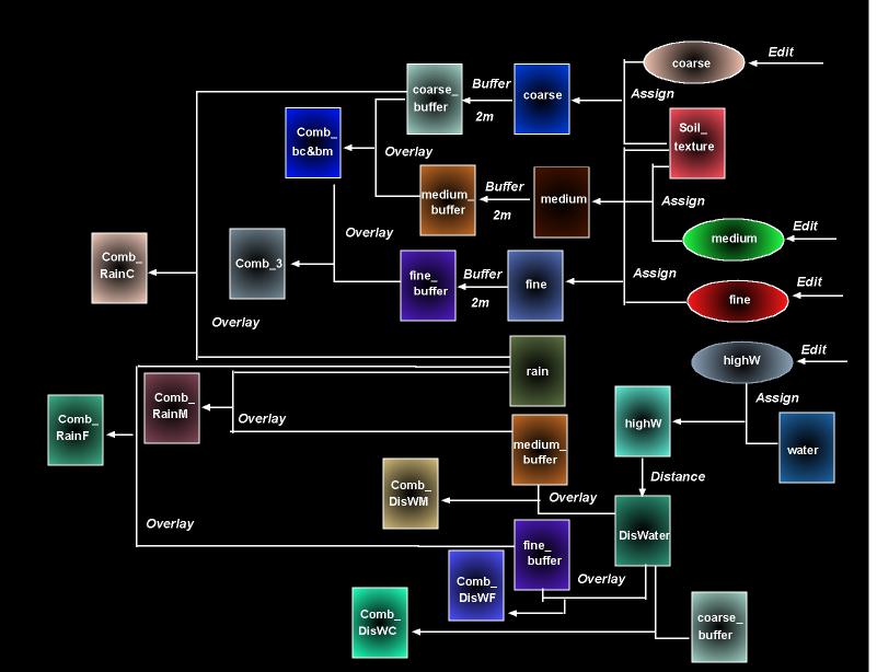
Cartographic
Model

The above
is the cartographic model of those images shown in the part of spatial
analysis. This model was produced with using the program, Freehand.
Because a model is much easy to be understood the processure of the images'
production, this model is shown firstly. Moreover, because of similar processures
of some images, not all images shown in spatial analysis are indicated
in the model, but they were described in the text version in the following.
Text
Version
1. Coarse
soil texture with its buffer (coarse_buffer):
- use
the operation, "Edit", to create an attribute value file
- use
the operation, "Assign", with the attribute value file and the layer
of soil texture to create a boolean map (0 and 1 legends)
- use
"Buffer"
operation
to set 2 meters from coarse soil texture in the boolean map
(see
the cartographic model above)
2. Medium
soil texture with its buffer (medium_buffer):
(same
processure as the above and see the cartographic
model above)
3. Fine
soil texture with its buffer (fine_buffer):
(same
processure as 1. and 2. and see the cartographic
model above)
4. Interception
of the three soil texture (Comb_3):
- "Overlay"
the
images of (medium_buffer) and (coarse_buffer) to create an image of interception
of these two soil texture (Comb_bc&bm)
- "Overlay"
the
images of (Comb_bc&bm) and (fine_buffer)
(see
the cartographic model above)
5. Precipitation
in areas with coarse soil texture (Comb_RainC):
- "Overlay"
the
images of (coarse_buffer) and (rain)
(see
the cartographic model above)
6. Precipitation
in areas with medium soil texture (Comb_RainM):
(same
processure in 5. and see the cartographic model
above)
7. Precipitation
in areas with fine soil texture (Comb_RainF):
(same
processure in 5. and 6. and see the cartographic
model above)
8. Distance
from surface water on coarse soil texture (Comb_DisWC):
- classify
the percentages of surface water (water)
- use
"Edit"
operation to create an attribute value for high % of surface water in (water)
- use
"Assign"
operation with the attribute value and (water) to create a boolean map
(highW)
- use
"Distance"
operation
in the image (highW) to create distance from surface water in Africa (DisWater)
- "Overlay"
the
images of (DisWater) and (coarse_buffer)
(see
the cartographic model)
9. Distance
form surface water on medium soil texture (Comb_DisWM):
(same
processure as above and see the cartographic
model)
10. Distance
from surface water on fine soil texture (Comb_DisWF):
(same
processure in 8. and 9. and see the cartographic
model)
11. Distance
from high potential evapo-transpiration (dishighpet):
- use
"Edit"
operation
to create an attribute value in (afpetann)
- use
"Assign"
operation with the attribute value and (afpetann) to create a boolean map
to show high PET as 1 legend (highpet)
- use
"Distance"
operation
with (highpet) to show distances from high PET (dishighpet)
12. Annual
average temperature on coarse soil texture (Comb_TempC):
- "Overlay"
the
images of (temp) and (coarse_buffer) to create
(see
the cartographic model)
13. Annual
average temperature on medium soil texture (Comb_TempM):
(same
processure as above and see the cartographic
model)
14. Annual
average temperature on fine soil texture (Comb_TempF):
(same
processure in 12. and 13. and see the cartographic
model)
15. Distance
from high water erosion (DisWaterero):
(same
processure in 11. and see the cartographic model)
16. Distance
from high severity of water effects (DisWindero):
(same
processure in 11. and 15. and see the cartographic
model)
All images
shown were added layers of African coastline (.vct) and African country
boundaries (.vct)
Next
Back
to Project Page
Back
to Home Page
