Introduction
The city of Vancouver and its surrounding municipalities is home to all types of weather that results from having mountains, rivers, an ocean, and a valley all in one area. People in the region associate different cities with different microclimates. A person on Burnaby Mountain may complain of the snow and fog, while another at the base of the North Shore lives with constant rain but is just happy not to be in Richmond were they might be facing a Fraser River flood. With this unique distribution of weather, the question becomes, where are the best and worst places to live in greater Vancouver if weather is the deciding factor?

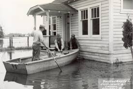
Image from The Chilliwack Museum
Any project looking at the distribution of weather events would be remise if it did not also consider the effects of climate change. As a result of an increase in global attention towards climate change there is a renewed respect for the power of the weather. With climate projections that predict increases in the frequency and magnitude of extreme weather, it is becoming clear that attention must not only be placed on how to prevent change but also on how to avoid the adverse effects of change.
Predicting the weather is a complex process and predicting the precise nature of climate change requires models that are beyond the scope of this project. However, by examining past trends and applying simple regression predictions can be made as to where certain types of weather phenomena are most likely to occur. With the exception of sea level rise, most climate change effects will be differences in the magnitude, extent, and frequency of current hazards. Therefore, in order to predict unsuitable locations for the future, it makes sense to map the distribution of weather in the present.