|
|
| Bowen Island Map Atlas Project |
| All of the data used to prepare this project, with the exception of the Digital Elevation Model used, came from the Bowen Island Map Atlas project, a citizen initiated project which has compiled many of the preexisting data sets for Bowen Island into a compact disk which can be ordered from the Bowen Island Geodatabase website (see references). All the data available through the Bowen Island Geolibrary was assumed accurate enough for planning at this scale, though it should be noted that some of the data was collected in 1979 and, as such, its comprehensiveness has been called into question (SEE 'ISSUES'). The Digital Elevation Model was taken off of the S drive data warehouse, and was cropped and reregisted using the RESAMPLE module in IDRISI to be the same resolution as the other data used in this project. |
| RESAMPLE PROCEEDURE |

|
| CONVERSION |
Despite the convenience of the Bowen Island Map Atlas project, much of the data in it contain irregularities which made importing them from ARC shape file formats into IDRISI difficult. All of the data were assigned the projection UTM 10N (some had undefined projections) using ARC toolbox and truncation of the associated attribute tables using Microsoft Access was also necessary as most contained multiple identical fields, which IDRISI will not accept as valid inputs.
With these problems solved, the needed data (as identified in the framework) was isolated or created from the shape files in the map atlas in ArcGIS. Though the Map Atlas contains a document which lists the contents of each of the layers, as a preliminary step the attribute data files for every layer were browsed.
The relevant data were queried from the attribute tables using the select by attribute tool and the select by location tool. In some cases, the data needed were not present, and had to be produced or approximated. Accurate and current information on the number and extent to which existing lots are developed is not available, for example, so already “developed” lots were assumed to be all those under 5500m2 (1.36 acres) as this encompasses most of the recent development on the island—on Bowen, further subdivision under this size is unlikely. A viewshed analysis, as well, is available as a consultants’ image which accompanies the OCP, but not as GIS data. It was therefore created using the VIEWSHED module in IDRISI.
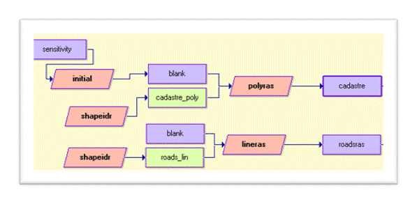
Once the relevant data were selected and exported, they were then converted through the SHAPEIDR module in IDRISI and registered to the blank raster file ALLBLANK so that each would share a common resolution and have an equal number of rows and columns (required for overlay operations).

How conversion was executed in IDRISI's Macro Modeller. The raster layer "SENSITIVITY" was used to register all the data converted from vector, through the file BLANK.
|
|
|

