 |
The
Most Suitable
Location to Grow Ginseng in Southern British Columbia |
|
|
The
Most Suitable
Location to Grow Ginseng in Southern British Columbia |
|
| Home |
Conceptual
Outline |
Data
Collection |
Methodology |
Spatial
Analysis |
Conclusion |
Problems |
| Spatial
Analysis |
||
| Weight Linear Combination (WLC) method
was used to determine the most suitable location to grow ginseng. Separate analysis was done for the criteria for the Commercial Point-of-view and the Traditional Point-of-view All four factors were used to create fuzzy images and then weighted according to there importance in the analysis. |
|||
|
|
|||
| Commercial Point-of-view |
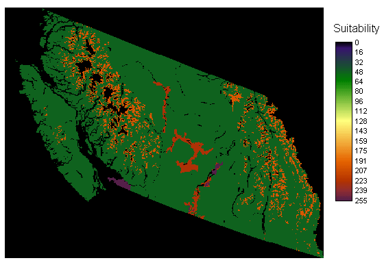
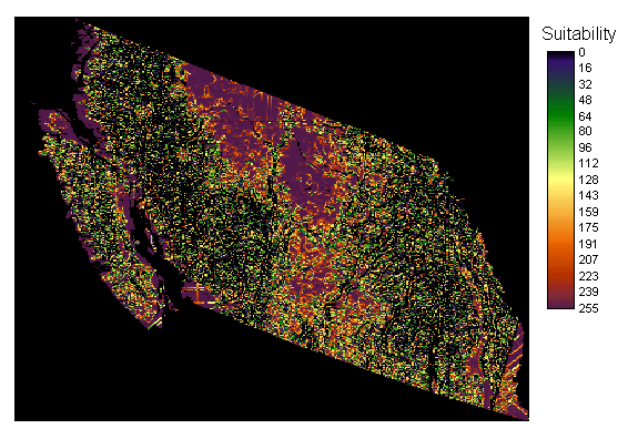
| This is the image
created for the
landcover, FuzzLandcover. It is a fuzzy map demonstrating the suitable areas (0-least suitable and 255- most suitable).This represents the most suitable place to grow ginseng from a commercial growers view point. |
 |
||
 |
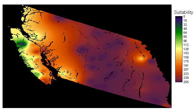
This image was
created to represent temperature, called FuzzTemperature. It is a fuzzy map demonstrating the suitable areas (0-least suitable and 255- most suitable). The control points started at -4 C to 3 C, therefore eliminating all temperatures below -4 C from the analysis. |
||
| This image was
created to represent precipitation, called FuzzPrecipitation.It is a fuzzy map demonstrating the suitable areas (0-least suitable and 255- most suitable). |
 |
||
 |
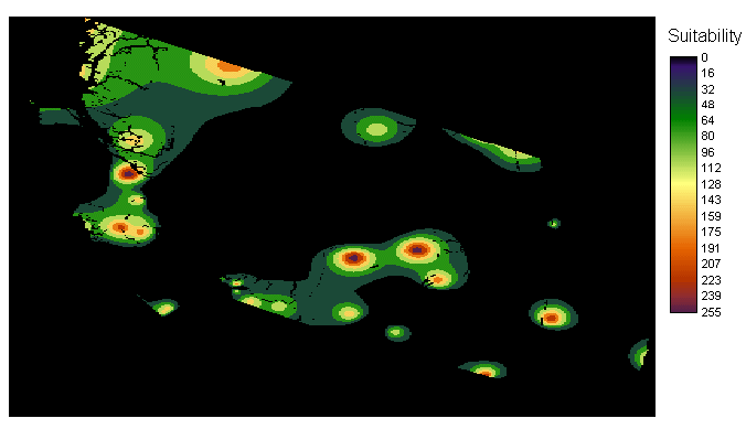
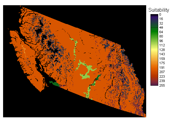
This image
represents the areas with the most suitable slopes, called FuzzSlope. It is a fuzzy map demonstrating the suitable areas (0-least suitable and 255- most suitable). This uses control points starting at 1 and going to 9, which represents the only possible slope that can be used. |
||
All four fuzzy maps were weighted according to the significance they play in determining the most suitable location to grow ginseng for a commercial grower. The slope is very important because it plays a large role in the start up and harvesting cost. The smaller the slop the easier it is to plow and harvest the land with machinery. Landcover type is also very important to the initial cost, how much the land must be cleared before start up. The temperature and Precipitation are important, but don't play the largest role. |
Factor Weights FuzzLandcover 0.25 FuzzTemperature 0.20 FuzzPrecipitation 0.20 FuzzSlope 0.35 |
||
| Top |
|||
|
|
|
| Traditional Point-of-view |
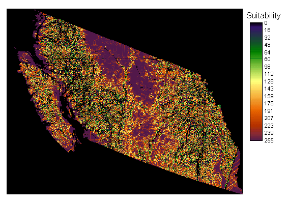
| This is the image
created for the
landcover, FuzzLandcover. It is a fuzzy map demonstrating the suitable areas (0-least suitable and 255- most suitable).This represents the most suitable place to grow ginseng from a traditional growers view point. |
 |
||
|
This image was
created to represent temperature, called FuzzTemperature. It is a fuzzy map demonstrating the suitable areas (0-least suitable and 255- most suitable). The control points started at -4 C to 3 C, therefore eliminating all temperatures below -4 C from the analysis. |
||
| This image was
created to represent precipitation, called FuzzPrecipitation.It is a fuzzy map demonstrating the suitable areas (0-least suitable and 255- most suitable). |
|
||
 |
This image
represents the areas with the most suitable slopes, called FuzzSlope. It is a fuzzy map demonstrating the suitable areas (0-least suitable and 255- most suitable). This uses control points starting at 1 and going to 15, which represents the only possible slope that can be used. This is a slightly larger range than used for the commercial point of view because it is less Dependant on slope. |
||
All four fuzzy maps were weighted according to the significance they play in determining the most suitable location to grow ginseng for a Traditional method. The landcover type is the most important criteria as the traditional method must be grown under a forest canopy. The next most important criteria is the precipitation, as soils can become more moist under forest canopies as there is less sunlight reaching the ground surface. Temperature is also important as not to damage the ginseng. The least important factor is the slope. |
Factor Weights FuzzLandcover 0.40 FuzzTemperature 0.20 FuzzPrecipitation 0.25 FuzzSlope 0.15 |
||
| Top |
|||
|
|
|
||
| Previous |
Next |
||