Spatial Error
ß
|
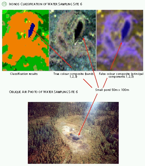
For each ground truth site corresponding image coordinates were located on the IKONOS imagery
to approximate ground truth site extent as indicated by corresponding colour photography. Each
colour photograph was taken from a helicopter and assigned accurate GPS coordinates. Presented
coordinates are of water sampling sites visible on the photography.
Accuracy of the coordinates of original data set is estimated between 50 and 360 m. Where
possible, satellite image features were matched to features visible on the photo 'near' the
given coordinates. Feature sizes were estimated on both the photo and images and compared for
shape and colour. Unfortunately, due to inadequate feature resolution some sampling sites
could not be precisely paired with known coordinates of IKONOS imagery. Inability to pair
coordinates resulted from either the presence of adjacent features of similar shape or possible
inaccuracies in coordinate data values.
Any classification is not meaningful until its accuracy is assessed (Hall, 1998). Error matrix
(or confusion matrix) compares on a category-by-category basis the relationship between known
reference data (ground truth) and the corresponding results of an automated classification.
At the end of each classification, the resulting thematic map was compared to available ground
truth data. The B/W air photographs were only of limited use because of their age and scale.
Errors are identified where classification clearly missed some land features.

When the Landsat image was classified based on training areas created only in Scotty Creek
basin, the classification results were inaccurate. The classifier confused many sparse coniferous
forests with channel fens anddecidous forests. The shallow ponds on the channel fen were not
properly classified because no such land cover classes existed in Scotty Creek basin. In the
second classification, the new class “ponds” was added. The highway was also not classified,
again due to lack of that type of land cover in Scotty Creek basin. After the training areas
were improved (more samples from outside Scotty Creek basin), the classification improved
considerably. On the colour photos, the deciduous trees appear as yellow due to change in
leaf colour in the late summer. Channel fen is an elongated brown coloured feature and
coniferous trees look dark green.
The sources of error in this classification can be attributed to several factors. In many cases,
the reflectance of one feature could be similar to the reflectance of another feature,
resulting in confusion. The similarity in reflectances could be the result of similar
background components and variations in tree density. Error could also be a result of
spectral mixing of various features that fall within a 30 meter pixel (Yamagata, 1996a).
This is particularly evident in Landsat pixels as compared to IKONOS pixels. The Landsat
Thematic Mapper sensor detects the combined reflected light from the 30 m by 30 m area.
As a consequence, if different landscapes are present, for example wetlands and forest patches,
then the resulting pixel might look as a “very green wetland” or “very wet forest”, and in
general create confusion during classification. In this way, many pixels will be improperly
classified.

Since the IKONOS raster has greater spatial resolution (4x4 m) than the Landsat TM raster
(30x30 m), the two images can not be easily compared through image overlays in IDRISI (IDRISI
user’s manual). The software requires that the overlay operation use raster images of the same
resolution and extent (number of rows and columns). Therefore, the two rasters must be brought
to the same resolution and size. This was accomplished using image expansion. Each pixel is
subdivided into smaller pixels. For example, if expansion factor is 4, each pixel is subdivided
into 4 x 4 = 16 pixels. Through image expansion, the IKONOS raster was converted to 2 m by 2 m
pixels (expansion factor = 2, given the original pixel resolution of 4 m x 4 m). For the Landsat
raster, the expansion factor was 15.

This statistical measure is an estimate of the difference between the observed accuracy and
the probability of chance agreement of classes (Lillesand and Kiefer, 1994). The Kappa
coefficient was estimated at 0.4979 for this cross tabulation. Barren land, water features,
and dense coniferous forests have the best match between the two images. For other classes the
match is poor.
It is very useful to visualize the errors between the two classification results. Two new
images were created using the image algebra and overlay operations in IDRISI. The details are
found in Project Diagram in the Appendix 3, and the results show images with four Boolean
algebra operations: pixels classified as Fen in IKONOS but NOT in Landsat, pixels classified
as Fen in Landsat but NOT in IKONOS, pixels classified as Fen in both IKONOS AND Landsat, and
other pixels (the negation of the “AND” operation on IKONOS and Landsat images). The same logic
follows for class of sparse coniferous forests, or any other class. Only class “Fen” and class
“sparse coniferous forest” were analyzed here.
|
