Spatial analysis of the eight layers that have been standardized was performed
using the MCE module using Ordered Weight Averaging (OWA). This module provides
the maximum control over how criterion are evaulated against each other. In
this analysis, two runs through the MCE-OWA were performed in order to simulate
different prioritization of factors. This prioritization relates to how factors
trade off against each other. This allows the amount of risk to be controlled.
First of all the WEIGHT module was used to weight each of the factors going
into the MCE. Weights for factors were given as the following:
The
consistency ratio for the weighting scheme was 0.09 which was rated as acceptable.
Clearly slope, house value and land use were the dominant factors in the analysis.
This was to reflect the realities of undertaking this type of project. Although
social considerations are introduced into the analysis, conventional concerns
are still of primary importance to siting a facility that is accessible and
relatively cost effective. Greater flexibility in how the factors traded off
against each other was provided in the OWA rankings.
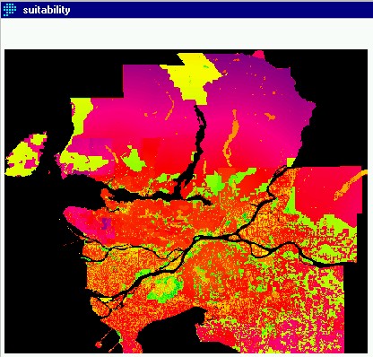
The
first run through MCE-OWA used weight rankings that allowed equal trade off
among all eight factors. This meant that each factor received a ranking of .125
This analysis was average risk, in that any factor could trade off with any
other factor. This produced the layer suitability shown below.
This
is a continuous layer showing suitability scores for each pixel, allowing factors
to trade off equally. This means that an low ranking in one factor at a given
location can be offset by a high score in another factor at the same location,
averaging out the between all eight factors. So even where landuse is not suitable,
scores are given as a degree of suitability. This poses a slight problem for
the analysis in that areas that have been designated as unsuitable are still
allowed into the analysis. Conventionally this is resolved by using the the
layer (landuse) as a constraint, however this would not allow trade off among
the uses that are suitable, nor would it allow us to see how results change
as the degree of trade off among factors changes. So to resolve this the landuse
constraint was brought in after the MCE analysis creating a layer called SUITFUZZ
and SUITFUZZ2 respectively for each of the MCE-OWA results. The only constraint
used in the actual MCE module was a reclassed boolean image called WATERCONSTRAINT
which masked out water areas. See the
cartographic model
for full depiction of spatial analysis procedures and layers.