Standardizing
Suitability for Landuse Layer:
The landuse layer standardized using EDIT
and ASSIGN. Landuse does not lend itself to continuous suitability as some
areas are simply not available for use, while others have widely vaying suitabilities.
Therefore the fifteen landuses were broken down into two categories; suitable
or unsuitable. From there the suitable uses were given a score between 1 and
255.
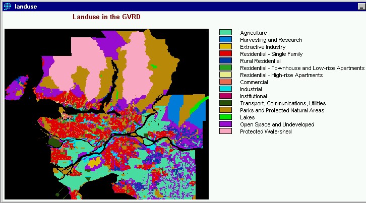
Suitable Uses
open space and undeveloped
industrial
extractive
institutional
Unsuitable Uses
agriculture
harvesting and research
residential single family
rural residential
residential (town houses)
residential (high rise)
commercial
transport, communications, utilities
parks and protected natural areas
lakes
protected watersheds
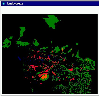
Suitable land uses were given the following scores:
open space and undeveloped - 255
industrial - 75
extractive - 100
institutional - 25
The
scores were developed with a few possibilities in mind. First of all open space
and undeveloped areas are the first choice and therefore receive the most suitable
rating of 255. The remaining three land uses represent possible opportunities
for changing existing land use. Industrial and extractive uses are for the most
part environmentally harmful and so could possibly be converted if public and
political support was sufficient. Institutional uses are included as suitable
as it may be possible to incorporate this facility into an existing institution
such as a university campus.
Here
is the standardized land use image. Clearly the amount of land available is
greatly reduced. These land uses will now be brought into the MCE-OWA analysis
along with the other standardized fuzzy layers. A full graphic representation
is available in the
cartographic model which shows the
sequential steps involved in making these layers and provides links to the images.
Further elaboration on the MCE-OWA analysis will be provided in the next section
on spatial analysis. The ice rink data was not incorporated into the MCE-OWA
analysis because it will be brought in after to evaluate the results of the
suitable areas based on Thiessen catchment areas of the existing ice rinks.
The final analysis is based on visual interpretation of the results of the MCE-OWA
analysis as digitized points, overlayed onto the Thiessen polygons derived from
the ice rink data. Using MCE-OWA for the next step allows the greatest flexibility
in evaluating suitability based on our criteria. Clearly the criteria are from
two separate but not necessarily mutually exlcusive perspectives; that of the
conventional developer, concerned with land value, slope, access, as well as
more socially based concerns, consistent with the obejctives of the Vancouver
Whistler Bid Committe, such as income and demographics.