I mainly found my background information on the Webpages of "RapidTransit" and "Translink" (www.rapidtransit.bc.ca, www.translink.bc.ca).
Furthermore I found information in the general literature on Planning Urban Transportation.
So I got basic information on my project like the information about the three main corridors Arbutus Street, Granville Street
and Cambie Street.
But as I stated before I found nothing on criteria to take into account when planning a skytrain route.
Therefore the literature was a little bit more helpfull.I just list some suggestions I found:
- regard Population
- regard Family and Household characteristics
- regard Labour Force
- regard Age Distribution
- regard Automobile Possession
- regard Employment
- regard Landuse (residential uses, non-residential uses)
- regard Travel Patterns
- regard Construction Costs
- regard Environmental Issues
- .....Some goals in Transportion include:
- increase accessibility to work
- reduce traffic
- reduce pollution
- reduce travel time
- reduce negative impacts on the neighbourhoods
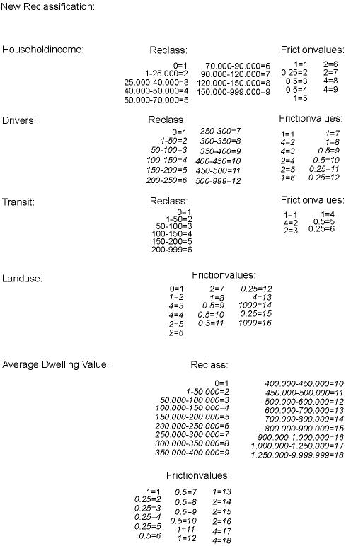
- ....With this in mind I looked at the data I had and identified the five criteria I used.
But still their was a problem left. How should I know the threshold values of all this criteria.
So the procedure of reclassifying my images to interpret them, and the assignment of friction values was
creative work. I based it on the general knowledge I gained throughout my students career.The explanation of my reclassification and the assignment of friction values relates to the final result and
does not take into account the previous reclassification (see Cartographic Model).
The final reclassification is as below.
The zero values are reclassed as a one because I am not allowed to have zero values in the friction surface.
I have chosen all the classes like this because they served the interpretation of the images very good.The next step was to develop an equal range of friction values:
0.25 0.5 1 2 4
Best Good Average Bad WorseI'm not going to explain all the assigned friction values. I just want to explain why the zeros (class one) got a
one as friction values. A zero value had all the Enumeration Areas whithout data information. So I assumed an
average cost to travel through it.In my Project Cost is not measured in time or monetary values. It just defines the suitability of an area for the
construction of a new Skytrain line.