Crater
Lake's History
"All ingenuity
of
nature seems to have been exerted to the fullest capacity to build a
grand
awe-inspiring temple the likes of which the world has never seen before."
-William
Gladstone
Steel, 1885
Crater Lake in southern
Oregon is the
site of one of the world's finest calderas. A caldera, as defined
by
Easterbrook (1999), is "a large 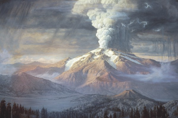 circular volcanic
depression the diameter
of which is many times greater than that of the included volcanic vent
or
vents" (524). This particular caldera, with a maximum width at
six
miles and a maximum depth of 1932 feet (Uhler,
2002) is the deepest lake in the
United States, and the seventh deepest lake in the world. The
elevation of
the lake is 6176 feet, and the highest point on the rim is Hillman
Peak, at 8151
feet (USGS,
2002). The lake averages 66 inches of rain per annum, as well
as an average of 44 feet of snow per annum (USGS,
2002).
circular volcanic
depression the diameter
of which is many times greater than that of the included volcanic vent
or
vents" (524). This particular caldera, with a maximum width at
six
miles and a maximum depth of 1932 feet (Uhler,
2002) is the deepest lake in the
United States, and the seventh deepest lake in the world. The
elevation of
the lake is 6176 feet, and the highest point on the rim is Hillman
Peak, at 8151
feet (USGS,
2002). The lake averages 66 inches of rain per annum, as well
as an average of 44 feet of snow per annum (USGS,
2002).
Up until approximately 7700
years ago,
Crater Lake was the site of a giant 12000 foot stratovolcano named Mt.
Mazama. A massive explosion
hollowed out the magma chamber inside of the volcano. This hollow
chamber
was not able to support the enormous weight of the volcano, and thus,
the
volcano collapsed. Further lava flows effectively sealed the
bottom of the
caldera. The impermeable rock allowed rainwater and snowmelt
brought the lake to
its current level.
An artists rendition of the Mt.
Mazama eruption, courtesy of the USGS.
There is no fluvial
output to
Crater Lake. That is, there are no creeks or streams to carry
water
away. How is it then, that with the massive snowmelt that enters
the lake
each year, that the lake remains relatively constant? The water
levels are
regulated in two ways: evaporation, and sub-surface seepage.
These two
factors are in relative equilibrium with the input of rain and snow,
hence the
level of the lake has very minimal variation from year to year.
How does the lake get its strikingly blue color?
A common
question that visitors
ask is "why is the lake so blue?" According to Warfield et. al
(1996), there are several factors. First of all, the lake has low
levels
of dissolved minerals, giving it no true color. Furthermore, its
low
concentration of suspended particles and organic matter give it the
deep
transparency. When light enters the water, some is absorbed, and
some is
scattered. Colors with long wavelengths (red, yellow, and orange)
are
absorbed within a couple meters of the surface. Greens are
absorbed
further down, but blues, which have short wavelengths, can penetrate to
120
feet. The water molecules can then scatter the blues from a great
depth. This gives the lake its intense blue color.
Return
to the intro
Back
to the main page
Reference: Easterbrook, D.J.
(1999). Surface
Processes and Landforms, 2nd ed. Prentice Hall, New Jersey.