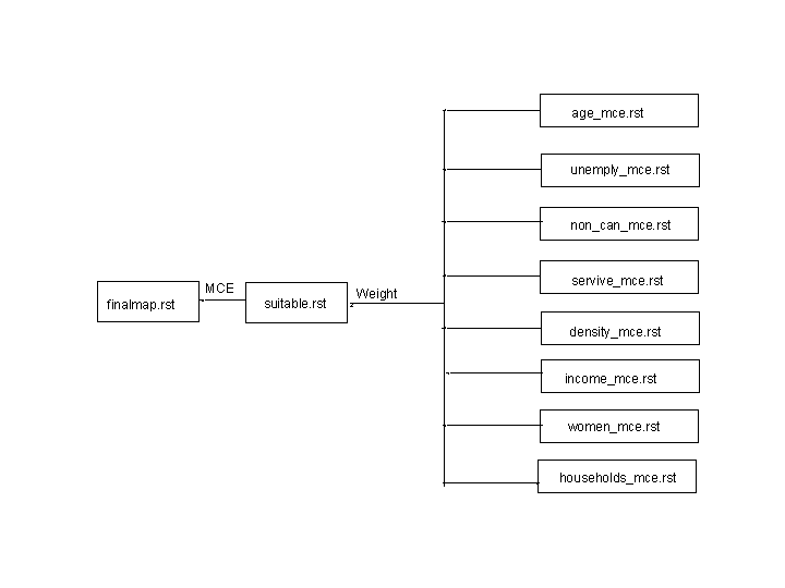
3. Methodology
The implementation of my project is divided
into two parts:
First, I wanted to analyse, if there are
any social factors which are dominating the areas 'Starbucks' are
located. And if so, what are these in detail?
Second, after determing the specific factors, which seem
to correlate with the location of the 'Starbucks', are there other areas
for placements of further 'Starbucks'? Has 'Starbucks' occupied all the
suitable parts of Vancouver or are some of them left?
For the first part of my analysis I had to manipulate the
data. I have already chosen the categories of the data I wanted to look
at. Moreover, I had to determine the composition
of each factor. Which are necessary and helpful factors, which of them are
useless for my project?
For my analysis I wanted to create different maps
all showing the impacts of one special social factor.
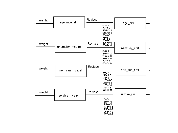
At least I chose the following factors:
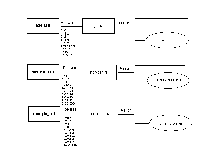
- Rate of Unemployment: One of my questions
was, if the Rate of Unemployment in one Census Tract of Vancouver influences
the decision of locating a new 'Starbucks'. If the Rate is high, won't
there be so many 'Starbucks', because people can't afford the money for
coffees? Or is 'Starbucks' integrated in everybody's life and also affordable
for everybody?
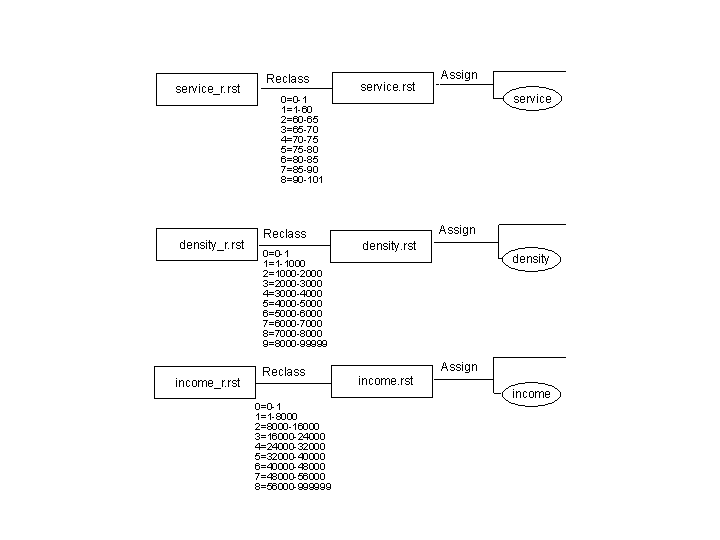
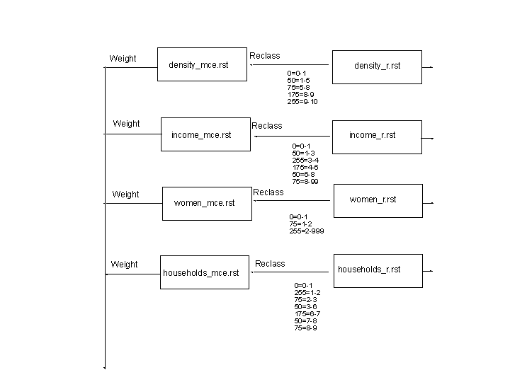
- Rate of Income: A following question was,
if the level of income influences the distribution of 'Starbucks'. Can
only people with a higher level of income afford this kind of coffee
or are these people rejecting this kind of lifestyle? - For this Rate
I created groups of Income.
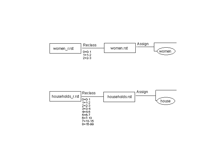
- Women/Men Ratio: It was thought as a kind
of a joke but I wondered if a majority of women or men
influences the locations of 'Starbucks' in a Census Tract.
I converted the absolute numbers of women and men of a Census Tract
into percentages - and was surprised getting the result!
- Rate of Non-Canadians: Have people of different
countries another relationship to coffee? Do Canadians love coffee of
'Starbucks' most? Or is coffee most preferred by other nations (maybe
not knowing this company before - like me)? - For the following
analysis I converted the absolute number of Non-Canadians
of a Census Tract into percentage.
- Main Group of Age: Do younger people consume
coffee most? Do the elderly reject this kind of coffee and prefer 'old-fashioned'
coffee? Consume people in the middle of their ages coffee on their way
to work? - For the following analysis I joined
different groups of age, because the units of the original data are too
small.
- Main Group of Households: Is 'Starbucks' located
where more single or more family Households are settled? Are singles
the typical consumers of coffee?
- Population Density: Does a higher Population
Density implicate a higher percentage of consumer? - To answer this question
I calculated the persons per squarekilometre.
- Rate of the Service Sector: Does a higher
Rate of the Service Sector mean more people are in this area during
the day? And as a consequence consuming more coffee and influencing
the locations of 'Starbucks'? - I divided
all the labor divisions into three categories: The first, second and
third sector and calculated the percentage of each of them.
I extracted the essence of those relationships (e.g.
the main group of age in a Census Tract where the most 'Starbucks' are
located is between 30 and 40 years) and made them to a principle influencing
the distribution of 'Starbucks'.
In my opinion the factors above give an overview of the criteria
influencing the locations of 'Starbucks'. Nevertheless, I know that a
high correlation can also be a result of coincidence...
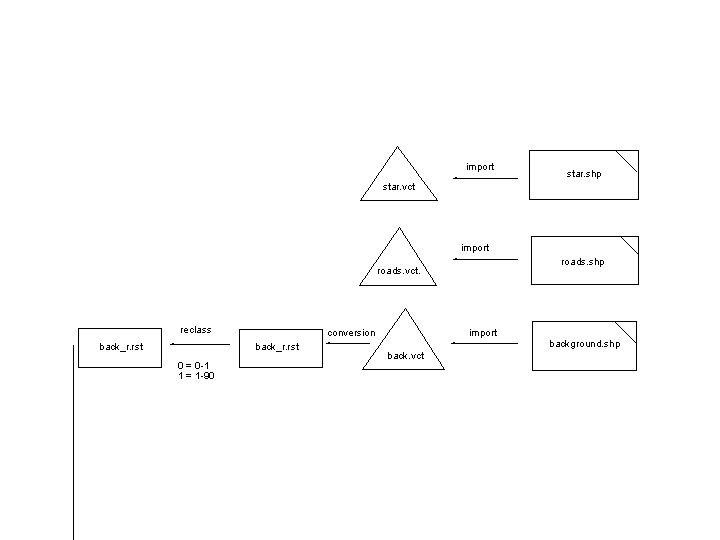
Carthographic Model