| Hawaii Statewide GIS Program.
information about our program and the Hawaii Geographic Information Coordinating Council (HIGICC) free spatial GIS data in ArcView shape file format and ArcInfo export format |
http://www.state.hi.us/dbedt/gis/ |
| Maui location map for beaches - links to beach descriptions and images | http://www.maui.net/~tkern/Beaches/BeachMap.html |
| Maui beach images and descriptions | http://gohawaii.about.com/travel/gohawaii/ |
| Maui beaches and beach rankings | http://www.beachactivityguide.com/Maui/Beach |
| all beaches in USA - links to various websites | http://www.oneweb.com/infoctrs/usa.html |
| Laboratory for Coastal ResearchUniversity of Maryland
- evaluations of "Best Beaches" in USA, based on various parameters |
http://www.geog.umd.edu/coastal/ |
| all about surfing and bodyboarding - links to webpages about beaches | http://surfing.about.com/recreation/surfing/ |
Imported GIS coverages:
Data downloaded from Hawaii Statewide GIS Program ( http://www.state.hi.us/dbedt/gis/
):
| Coastlines | Line | USGS Digital Line Graphs, 1983 version |
| Reserves | Polygon | Bird sanctuaries, marine parks, state parks, historic parks, etc...
digitized from various sources - incomplete |
| Land use | Polygon | State Land Use District Boundaries
for the 8 main Hawaiian Islands, as of May, 2000. digitized from State Land Use Commission 1:24,000 mylar maps |
| Islets | Polygon | Small islets surrounding coastlines of the main hawaiian islands
USGS Digital Line Graphs, 1983 version. |
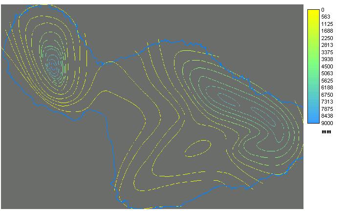
| Elevation: 500 foot contours for selected islands | Line | contoured elevations from USGS Digital Elevation Models (DEMs), 1:250,000, 90 meter, 1983 version |
| Solar Radiation: estimated daily insolation contours | Line | Data digitized by OSP staff from the 1985 paper sunshine maps, produced
by the Department of Planning and Economic Development, Energy Division |
| Precipitation: median annual rainfall contours | Line | Office of Planning, State of Hawaii |
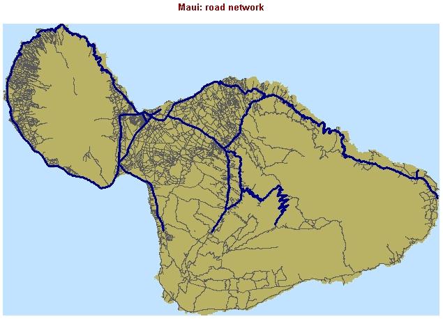
| Major roads | Line | extracted from the USGS 1983 DLGs for the main hawaiian islands, USGS Digital Line Graphs, 1983 version |
| Roads | Line | extracted from the USGS 1983 DLGs for the main hawaiian islands, USGS Digital Line Graphs, 1983 version |
| Trails (hiking) | Line | Na Ala Hele State Trails and Access System
State Department of Land and Natural Resources, DOFAW, 2000 |
| Coastal Place Names | Point | 'Reference Maps of Hawaii,' University of Hawaii Press, 1989
digitized by Office of State Planning |
| Coastal Resources | Point | (board surfing, diving, fishing, ...)
Maui Resource Atlas' Harbors Division, 1981 digitized by Office of State Planning, 1989 |
| Principal Bodysurfing Sites | Point | with site ratings of cultural significance and ability level required
source: Statewide Recreation Resources Inventory: |
Projection: Universal Trans Mercator, Zone 4