Cartographic model:
|
|
Create friction surface for the time of travel:
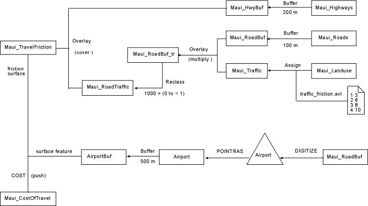
| Create buffers around roads and highways,
and combine both images into one. Buffer around roads is 100 m, and
around highways 200 m (this is necessary because smaller buffers did not
produce appropriate results in later analysis). Specify that highways
and buffer have cell value of 1, and roads also have cell value of 1 (these
will be modified later).
Maui_Roads.rst ------ (BUFFER) ------> Maui_RoadBuf.rst
IMAGE
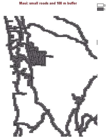
These two images can be combined in map composition to show road
transportation network of Maui. IMAGE
|
|
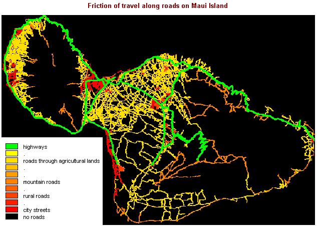
Create traffic friction areas from landuse image so that urban areas
have the greatest friction to travel because of city traffic congestion,
and all other areas get much less traffic. The landuse codes were:
(1) agricultural, (2) conservation, (3) rural, (4) urban
agricultural = little traffic and flat, friction value 3Maui_Landuse.rst -------- (ASSIGN) ---------> Maui_Traffic.rst ( traffic_friction.avl ) |
traffic_friction.avl
1 3 2 6 3 8 4 10 |
| Overlay the road image with landuse image and multiply
all cells. The road cells take the values of traffic friction (landuse)
cells because road image has values 1 for roads and 0 for other areas.
The roads will have values from 5 to 10 corresponding to different traffic
frictions (landuses).
Maui_RoadBuf.rst (multiply) Maui_Traffic.rst ------ (OVERLAY) -----> Maui_RoadBuf_tr.rst The areas between roads can be considered as barriers to travel, and they need to have very large friction values. Simply reclass the image so that values 0 to less than 1 (which means 0 values only in this integer value image) take value of 1000. Maui_RoadBuf_tr.rst ------ (RECLASS) ------> Maui_RoadTraffic.rst
|
|
| Now, overlay the highways and roads into one image:
Maui_HwyBuf.rst (cover) Maui_RoadTraffic.rst ------ (OVERLAY)
------> Maui_TravelFriction.rst
IMAGE
|
|
Digitize airport location:
| Digitize Kahului Airport location and create 500 m buffer around it
to represent its size (ensures that it connects with roads) use Maui_RoadBuf.rst
as basemap:
digitize point feature and save as new point vector layer (e.g. Airport.vct)
(DIGITIZE) -----> Airport.vct ------ (POINTRAS) -----> Airport.rst
----- (BUFFER) ------>
AirportBuf.rst
|
Calculate cost of travel image:
Calculate cost of travel from Kahului Airport along the road network
(use cost push algorithm):
surface feature image: AirportBuf.rst |
| To show ocean and land as different colours, overlay two images where
ocean pixels have value of 1 in covering image, and land pixels have value
of 0 so the other image (cost of travel) shows through:
MauiCoasts_inverted.rst (cover) Maui_CostOfTravel.rst ----- (OVERLAY) -------> Maui_CostOfTravel2.rst Create map composition for cost
of travel from Kahului Airport IMAGE
|