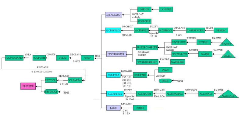
Legend: green=intermediate steps, purple=constraints, blue=factors, magenta=final image
In order to achieve the results that I wanted I decided
to use Multi-criteria Evaluation as it incorporates both factors and constraints.
At first soil type was the only factor I had, but then with further evaluation
I decided that slope and distance from roads were also factors. My remaining
criteria had to be designated as constraints as development cannot take
place in water or in a buffer zone. Also, I wanted my course to be on undeveloped
land so that perhaps a new subdivision can be built around it which would
in turn gentrify the area.
The Cartographic Model of my project
Legend: green=intermediate steps,
purple=constraints,
blue=factors,
magenta=final
image
Factors:
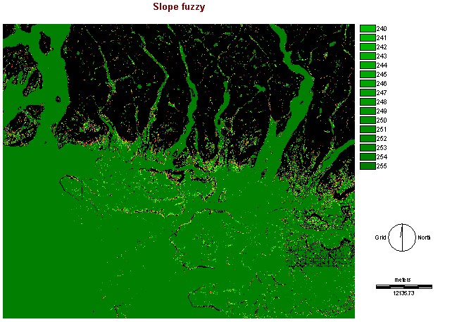
Slope
The SLOPEFUZZ1 image was created
using the DEM of the Lower Mainland. This was very easy compared to creating
the slope map by hand which I've done and it is no simple task and very
time consuming, about 100hrs for a 3ft x 4ft map! The SLOPE module in IDRISI
accomplishes this task in a matter of seconds, however it is known that
maps created by hand tend to be more accurate. The next step was
to isolate the desirable slope percentage, in my criteria I decided that
3% was a minimum, so using RECLASS areas with a slope of less than 3% were
classified as '0' so they would not count. The FUZZY module was then used
as I wanted a varied slope to my area so I used the sigmoidal curve with
10 and 20 as my control points. 10 because slope less than 10% is
not very challenging and 20% as a maximum as a slope any higher would likely
make the course too challenging and the players would get discouraged.
Finally, I had to change the projection of the image to ensure that it
was the same as my other criteria so that I would be able to combine them
together using MCE.
Here is the image I came up with:
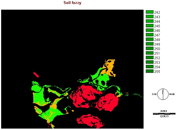
Soil Type
The ideal type of soil was determined to be sandy
loam. In order to get this image to work properly a lot of time was spent
on reworking the database. The image from the S: drive of soils gave each
plot of soil a unique identifier and did not group anything together. There
was a field in the database for soil type except that it was by description
and not integers. So, I created a new field to do this using the SQL calculator
in Database Workshop to give the following: 1=sandy loam, 2=silty to clayey
loam, 3=sandy to silty loam, 4=silty loam to clay loam. I decided to allow
the use of various types of loam in order to be more accommodating and
since there was only a small portion of land designated sandy loam that
may not fit with the rest of my criteria. Once my field was created it
needed to be linked to something to display it. At first Aparna suggested
to save the database as a .dbf file, open it in MS Access, convert into
MS Excel to eliminate unnecessary fields, then to save it as a .txt file
and finally a .avl file. However, being someone who believes in efficiency
I figured that there had to be an easier way. After much fussing I found
that the Database Workshop exports .avl files directly! I used the idrisi_ID
file as the link file and my created SOILTYPE as the data file, and voilà,
it worked! The soils.avl file was used in ASSIGN to create the image SOILTYPE.
In order to make this image useful for MCE I used RECLASS to assign weights
to each soil type to produce the following image:
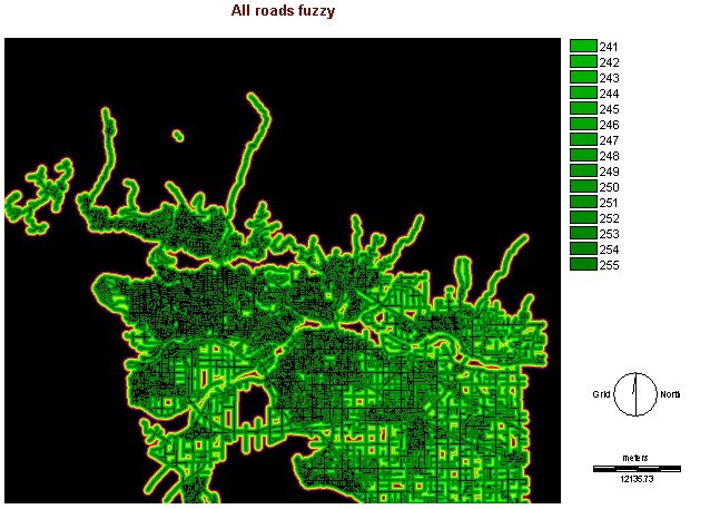
Roads
Roads are significant to the location of the golf
course in two ways, proximity to make driving to easier and buffer zones
to make sure that there are not any car windows broken by stray balls (or
bad players!). The ALLROADS image from the S: drive was in vector format
so I had to convert it into raster format before i could perform any operations
on it. Once the image was rasterized I used the DISTANCE module to measure
the distance between the cells. Then RECLASS was used to create a buffer
zone of 50m around the all roads. Finally, the FUZZY module was used with
a sigmoidal curve using 50 and 1000 as control points. Since there were
no longer distances below 50 it was treated as a minimum and 1000 was used
as a maximum since people are already driving far enough from the existing
course and the longer the road to the course the more expensive. Here is
the image I created:
Constraints:
Landuse
The LANDUSE image came from the S: drive,
RECLASS was used to isolate the OPENSPACE layer into a boolean image. I
only used this layer as there were not any layers for former industrial
land. This layer was then overlay with the NO PEOPLE image to ensure that
the land was uninhabited. This image was produced:
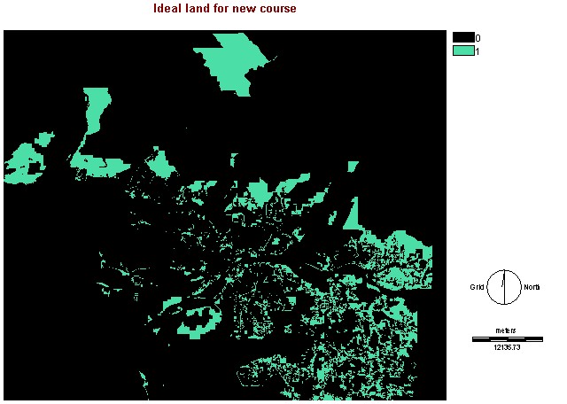
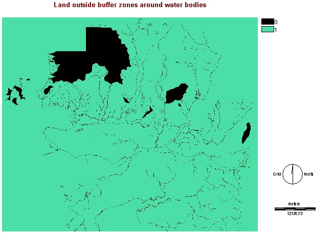
Water bodies and Watersheds
Three images were used to create the WATERSBUFF
image. The RIVERS and WATER were rasterized using parameters from the IDEALLAND
image. Then then a 30m buffer was applied to each and then they were overlaid
to create WATERCOMBUFF. This image was then overlaid with a buffered WATERSHD
image to create WATERSBUFF:
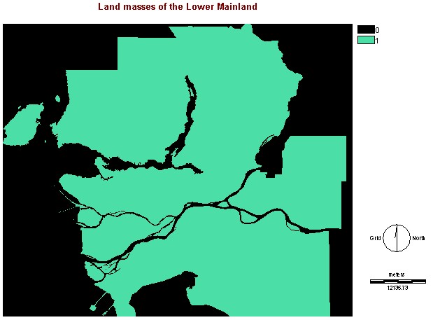
Land
After all the images were created I realized
that my water layers included the Fraser River, Burrard Inlet and other
water bodies surrounding the Lower Mainland, so I created the LAND image
by applying RECLASS to the CITIES image to isolate the land masses.
Multi-criteria Evaluation:
As noted above the three factors were slope, soil
type and roads. These were assigned the following weights 0.1702, 0.7383
and 0.0915 using the WIGHT module. I chose these weights as I thought
that it was more important to have the proper soil in order to maintain
a good-looking course that people would want to play on. Slope was second
as it is more variable since the greater the slope the more challenging
the course, also once can always remove soil to change the slope whereas
changing the soil type may be more difficult. Roads was put as least important
as it is more ideal to have a good location based on the other factors
to make it worthwhile to travel to than to have a poor location that is
easy to travel to.
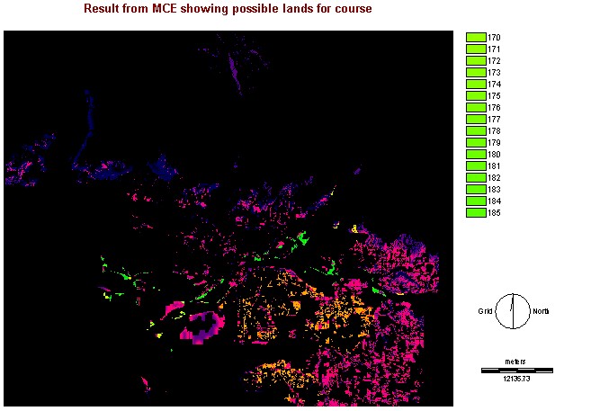
The image that resulted from the MCE did not explicitly
show where the best location would be, but just a bunch of locations with
varying weights so more analysis needed to be performed. Firstly, I tried
to group the areas so that I could fulfill my last criteria of size, however
this was not possible as there were to many areas and IDRISI could not
compute them all. I then used RECLASS to eliminate the areas of least fit,
I chose to eliminate those lower than 75 as I wanted to keep as many options
open as possible because there did not seem to be many large areas that
fell into the most desirable range. The areas were then grouped to include
diagonals and then the AREA module was executed calculating in acres.
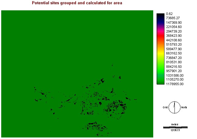
This module computed the size of all the areas including
the area outside the weighted sites as a whole. To remove the outer area
as a potential site RECLASS was used to produce the following:
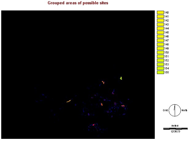
Now, my last criteria could be fulfilled. Sites smaller
than 120 acres would not be able to accommodate a full 18 holes along with
essential amenities that a first-class country club requires so RECLASS
was used once again to eliminate sites less than 120.
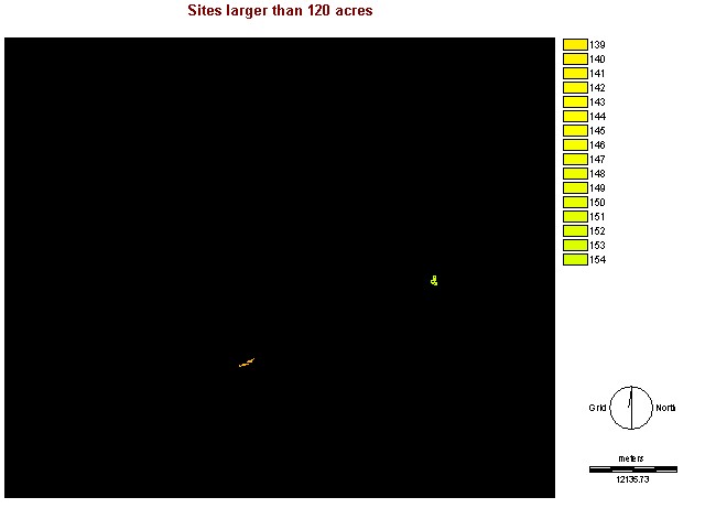
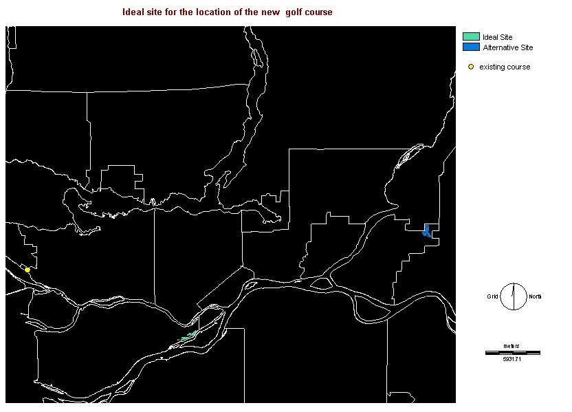
Site Choice
Two sites were left over after the RECLASS and to
make the image easier to read ASSIGN and Edit were used to designate the
preferred site and the alternate site should the preferred one not be available
for purchasing. This final image was enhanced by adding the CITY vector
layer and digitizing a point to show the location of the existing course
for reference. The preferred site was chose due to its proximity and ease
to travel to from the existing site as it is assumed that most of the members
are from the area surrounding the existing site. The alternate site is
much further away and more difficult to travel to as almost 5 cities need
to be crossed and traffic is almost always heavy. As it happens this site
is close to industrial land and a golf course in this location would definitely
help beautify the area, especially if more land surrounding it was purchased
and a subdivision like Morgan Creek in Surrey was created. This area is
also slowly being developed by the City of Richmond and a residential suburb
is located nearby.