Data Compatibility
Data CompatibilityProjection ProblemsThe two main online data sources with the greatest reserve of data that I needed for this project wereBase DataData from the Oregon Geospatial Data Clearinghouse is encoded with a "Special" Lambert Conformal Conic projection for Oregon. However, some of the data available on the web site is derived from other sources, such as the USGS, and comes in a different projection that is unspecified because metadata is not provided on the Oregon site. Because of this ambiguity, many of the data themes that I needed were unusable because I could not re-project them using Idrisi's PROJECT module because information regarding standard parallels, the ellipsoid, parameters, etc. necessary to create a projection reference file were unavailable or vague.
* EXCLUDING climatic data obtained from OCSThe same problem applies to data from the BLM, which also used its own in-house projection for all of its data. When viewing some of the metadata for various coverages, all of the pertinent information was there, whereas for others, it was incorrect or missing. For example, certain metadata files indicated that a particular coverage had a different standard parallel than other files when it fact the theme adhered to the standard projection encoded with the majority of BLM data. This made bringing data into Idrisi very tedious and difficult because it resulted in a trial-and-error process of changing/fine tuning reference files for certain coverages, and then attempting to re-project them until all of my BLM data would overlay.
Because of data issues pertaining to projections, I chose to download as much as I could from the Bureau of Land Management instead of both the BLM and OGDC in order to minimize computability problems.
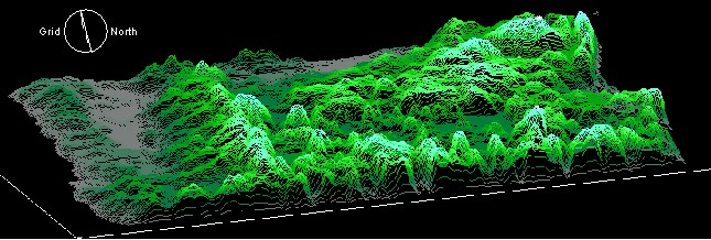
 I decided to create a DEM that I could use to display as both an ORTHO and act as a base layer onto which I could project other thematic layers. The DEM was created by obtaining 50-foot interval contours from the BLM, and converting them into shapefile format. In ArcView, I edited the attribute table for the arc coverage, and created a new numeric field into which I populated with numeric versions of the text/character format numbers that identified the contour value (i.e. 4500 ft, 5000 ft, etc.). I used this new field from which values were assigned to the cell once I converted the vector shapefile to a gird using ArcView's Spatial Analyst extension. This grid was imported into Idrisi as an ASCII raster, and subsequently filtered several times with both mean and Guassian filters. Problems arose because flat land had been assigned a value of "0" in the original data, so both areas outside of the map perimeter as well as plateaus were assigned the same value. Once I had run a series of filters to close the Oregon perimeter, I employed Idrisi's Pit Extraction surface analysis model to assign a height value to plateaus, and reclassified the image to take care of large -9999 values that indicated the background/lack of data by assigning these values a value of -1.
Digital Elevation Model of Oregon
ErrorBecause I did not employ an algorithmic model to conduct my analysis but rather assessed criteria upon which such models are based, the arbitrary weights assigned to the criteria in the Weighted Linear Combination reduce the accuracy of the analysis result. The success of this project lies in the integration of the multitude of environmental factors that vary in the degree in which they influence the susceptibility of an area to experiencing forest fire. My intention in pursuing this project was to demonstrate my ability to manipulate data according to criteria that was thoroughly researched and assessedi nstead of entering data into an existing algorithmic model in order to obtain the most accurate result possible.