![]() The main sets of data used in this analysis are distributed by the BC government. They include:
The main sets of data used in this analysis are distributed by the BC government. They include:
1. BTM: Base Thematic Mapping Data:
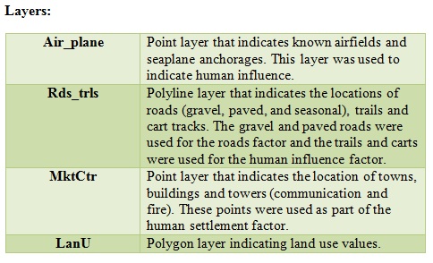
The BTM data documents present land use. This data base consists of Vector PLU data and their associated attribute data bases. This data was compiled from Landsat TM 5 imagery from 1992-1999 at the scale of 1:250,000 on Federal Government NTS re-structured maps. The province is currently developing more current BTM versions, but these were unavailable for the map sheets used in this project. BTM Data originally were in Arc View Shape File, format (*.e00). The data were imported into Arc View using Arc View Import. Individual map sheets were merged into one large map sheet using GeoProcessing extension and converted from Albers Equal projection into UTM-9 using the BC Albers Tool Extension. The data structure was originally Polygon vector file with a linked database. The land sat data used to derivate this data range in age from 1992-1994 depending upon the map sheet (1992:102P, 92M, 93D 1994:103A, 103H). Production dates for all map sheets was 1996. The BTM data were used to indicate land use classifications, locations of human settlements, areas of human influence, location of old forest, and location of roads. The BTM themes were imported into Idrisi as SHAPEIDR using ESRI Software Specific Formats. Parameters were defined from the DEM when layers were converted into raster format.
[Click on image to enlarge]
2. Watershed Atlas:
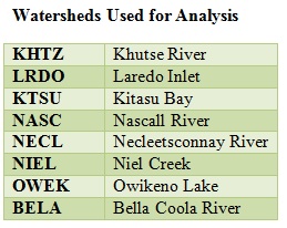
BC divides the province into 246 watersheds that are used as a foundation for the province's regional planning and management. Data for the 8 watersheds used in this analysis was downloaded from the government web site. ftp://ftp.elp.gov.bc.ca/dist/arcwhse/watershed_atlas/ Watershed Atlas Data originally was in Arc View Shape File, format (*.e00). The data were imported into Arc View using Arc View Import. Individual watershed files were merged into one spatial data set using GeoProcessing extension and converted from Albers Equal projection into UTM-9 using the BC Albers Tool Extension. This database consists of a series of point, polyline and polygon files that depict all 1:50,000 aquatic related line work, stream centerlines and watershed boundaries. Data were collected for all 8 watersheds within this study and merged using geoprocessing wizard to create one dataset. The file containing the polygon shape file, lwlb, outlining the perimeter of the watersheds was converted into a perimeter polyline and imported into Idrisi. The original polygon shape file was also imported into Idrisi. The Watershed themes were imported into Idrisi as SHAPEIDR using ESRI Software Specific Formats. Parameters were defined from the DEM when layers were converted into raster format. The positional accuracy is slightly less than the standard accuracy of the 1:50,000 NTS source maps. 68% meets +/- 25-50m horizontal positional accuracy. The data were scanned from Mylar separated of NTS 1:50,000 map series.
[click on image to enlarge]
3. DEM * TRIM Data: 25 meter DEM
The Digital Elevation Models were collected for the following map sheets: 102P, 92M, 93D, 103A and 103H. They were viewed in Arc View as a grid file by enabling the spatial analyst extension. Data sets were merged using GRID MOSAIC (AS10017) Arc Script downloaded from the ESRI website. This script enabled seamless merging of Grid themes. The Resultant DEM was then clipped using the Script CLIP GRID (AS10159) in order to eliminate areas outside of the analysis. Both scripts were in Avenue language. The complete DEM was exported from Arc View as an ASCII file and imported into Idrisi as an ARCRASTER image using ESRI Software Specific Formats. The DEM served as the base layer from which all other layers were defined. Its projection was originally UTM-9. The 30 m scale of the DEM determined the spatial resolution of the project.
4. FISS: Known Fish Distribution Map Data.
Each of the provinces 246 watershed groups has three categories of 'known fish' associated with it. This includes salmon, sport fish and lake fish. This data is stored as ARC/INFO interchange files (*e.00) in Albers projection. The polyline used for this analysis contained information on known fish spawning and distribution zones. The location of Salmon runs was differentiated from Sport fish and used for the Salmon Factor of the analysis. FISS Data originally were in Arc View Shape File, format (*.e00). The data was imported into Arc View using Arc View Import. Individual map sheets merged into one large map sheet using GeoProcessing extension and converted from Albers Equal projection into UTM-9 using the BC Albers Tool Extension. The data structure was originally a polygon vector line file with a linked database. The Fish theme was imported into Idrisi as a SHAPEIDR using ESRI Software Specific Formats. Parameters were defined from the DEM when layers were converted into raster format.