Data Processing
Base File Processing
 The
geographic base files provided by DMTI Spatial include both a point file showing
the centroids of six-digit postal codes, or "local delivery units"
(e.g. V5A 1S6), as well as a detailed street network file including civic
addresses in the proper form for geocoding. Initial surveys of the data revealed
that many of these addresses had been entered in forms that were ambiguous,
or poorly organized. As such, patients were geocoded via postal code instead
of by street address. Postal codes provide a sufficient degree of locational
precision, while at the same time facilitating ease of linkage between tables,
given that there is a standard, six-digit form for all postal codes, and that
each postal code is unique to a specific local delivery unit (LDU).
The
geographic base files provided by DMTI Spatial include both a point file showing
the centroids of six-digit postal codes, or "local delivery units"
(e.g. V5A 1S6), as well as a detailed street network file including civic
addresses in the proper form for geocoding. Initial surveys of the data revealed
that many of these addresses had been entered in forms that were ambiguous,
or poorly organized. As such, patients were geocoded via postal code instead
of by street address. Postal codes provide a sufficient degree of locational
precision, while at the same time facilitating ease of linkage between tables,
given that there is a standard, six-digit form for all postal codes, and that
each postal code is unique to a specific local delivery unit (LDU).
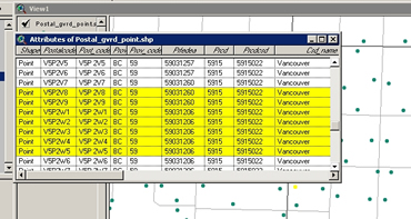
Postal codes (or local delivery units) were provided
by DMTI Spatial as point form data. Included among the attributes for this
dataset was a field indicating which enumeration area (EA) each postal code
is contained within. 1996 Canadian Census enumeration area shapefiles were
matched using the EA as the common identifier.
Matching the TB Dataset to Postal
Codes
 Joining
the postal codes of all of the patients to the DTMI Spatial postal code shapefile
allowed for the commencement of visualization and spatial analysis. As there
were multiple patients in 38 postal codes, a "count" field containing
the number of patients per postal code was added. This provided an indication
as to the density of patients in any given postal code. Once the postal codes
were joined to the spatial shapefiles, we were able to compare individuals'
addresses to their postal codes. Several EAs containing patients did not contain
any socio-economic data in the dataset. Thus, socio-demographic and economic
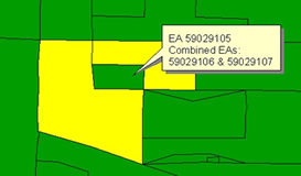
data had to be manually assigned. Initially, a point-in polygon search indicated
14 tuberculosis patients residing in 'blank' EAs. Rather than discount these
patients, we assigned values to the EAs based on averages of the surrounding
EAs. For example, for EA 59029105, we chose the nearest neighbours, 59029106
and 59029107.
Joining
the postal codes of all of the patients to the DTMI Spatial postal code shapefile
allowed for the commencement of visualization and spatial analysis. As there
were multiple patients in 38 postal codes, a "count" field containing
the number of patients per postal code was added. This provided an indication
as to the density of patients in any given postal code. Once the postal codes
were joined to the spatial shapefiles, we were able to compare individuals'
addresses to their postal codes. Several EAs containing patients did not contain
any socio-economic data in the dataset. Thus, socio-demographic and economic
data had to be manually assigned. Initially, a point-in polygon search indicated
14 tuberculosis patients residing in 'blank' EAs. Rather than discount these
patients, we assigned values to the EAs based on averages of the surrounding
EAs. For example, for EA 59029105, we chose the nearest neighbours, 59029106
and 59029107.
Data Scrambling
In the interest and necessity of protecting the
privacy of patients, especially patients of potentially controversial diseases
such as tuberculosis, direct point mapping was avoided as it may have facilitated
the direct identification or location of individual patients.
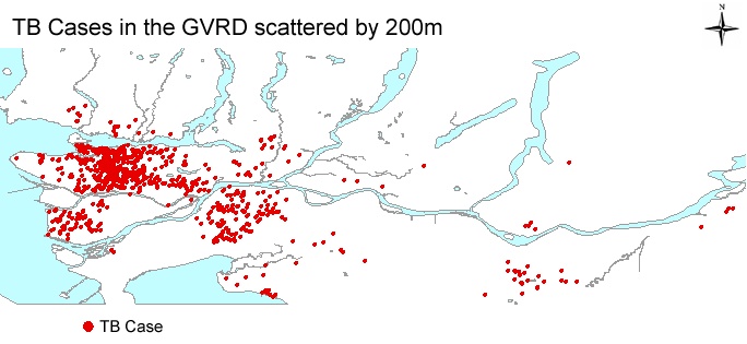
For the purposes of visualization only, a scrambling
program was developed in Avenue (ESRI's ArcView GIS 3.2 object-oriented programming
language). By developing a script based on the Number.MakeRandom operator,
a random 'scrambler' was added to the actual X and Y coordinates of each point,
effectively moving the points to within a 200-metre square of their initial
location. This level of scrambling is the equivalent of one to two city blocks,
and was deemed to be sufficient in areas with population density, such as
the Downtown Eastside or parts of Mount Pleasant or Central Burnaby. The number
of possible addresses for each "dot on the map" is, of course, quite
high in these areas, high enough to ensure a sufficient level of privacy.
In outlying areas, however, scrambling the locations
by 200 metres is far from sufficient to protect the privacy of patients not
residing in densely populated areas. As a result, for views of outlying areas,
points were scrambled by 400 metres.
Data:
Sources | Study Area | Processing
Home
| Introduction | Background
Objectives | Data | Analysis
| Error | Conclusions
Links | References
| Contact