Spatial Analysis
3.1 MCE Boolean Intersection
3.2 MCE Weighted Linear Combination
3.3 Final Results

Spatial Analysis
3.1 MCE Boolean Intersection
3.2 MCE Weighted Linear Combination
3.3 Final Results
3.1 MCE Boolean Intersection
I chose 6 factors to help in the decision of where the site should go. To conserve space on this page, I just included a small version of each picture. To see a larger version of pictures, simply click on the image. To view the cartographic model of the Boolean Intersection Evaluation, click here.
As there is the necessity of using salt water to swim the seals and this is continually being added and drained, a buffer of 200 meters was made around all water in the GVRD.
The ideal site would be on undeveloped land. Since this may not be possibly, also taking industrial and transport/communications into account. Normally would not have considered transport but the existing Rehabilitation site is on this landuse type. This was done through assigning wanted land to 1 and the rest as 0.
As the site is a quarantined rehabilitation site, I chose to make a 50 meter buffer around areas where people live just to be on the safe side. Having the site close to people brings more risk to the exchange of disease.
Being close to a road is a primary concern as there is transportation of sick or injured animals. Also, it is easier to locate a site where there is already access to roads. With this in mind, there was a buffer of 200 meters placed on all roads in the GRVD.
The site needs to be on a flat surface in order to keep the buildings and pools level. I used the VanDEM to calculate the percentage slope and reclassed slope under 5% as 1 and everything else as 0.
Since I take the bus to volunteer there, I decided this was a criteria (as I am the one who is designing the locational criteria). Using Translink data for all bus routes in the GVRD, I placed a 500 meter buffer around all bus routes.
Results:
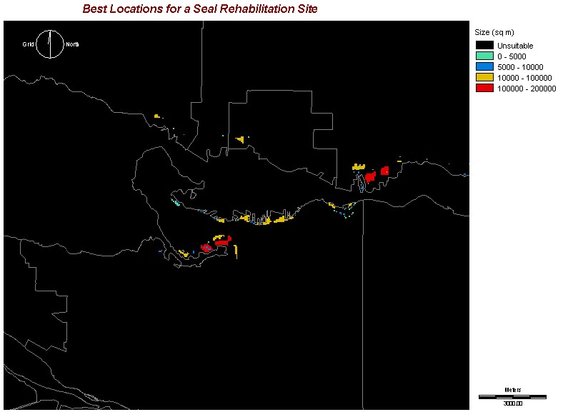
After doing the MCE Boolean Intersection Evaluation (see above image), I noticed there were quite a few locations possibly along the Fraser River, which is fresh water. Because of this, I isolated it so that only Vancouver, North Vancouver, West Vancouver, Burnaby, Richmond, and New Westminster were possible cities for the site to be on. Following that, I grouped and calculated the areas of each group. In the following image, you can see a general trend of possible locations. They are primarily around False Creek and the industrial parts of Burrard Inlet.
